You are here: Home > Network List > TA - USArray Transportable Network (new EarthScope stations) Stations List
> Station M02C Callahan, CA, USA > Earthquake Result Viewer
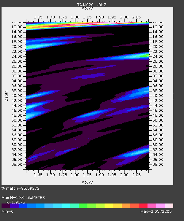
M02C Callahan, CA, USA - Earthquake Result Viewer
| Earthquake location: |
Hokkaido, Japan Region |
| Earthquake latitude/longitude: |
43.9/142.5 |
| Earthquake time(UTC): |
2011/10/21 (294) 08:02:37 GMT |
| Earthquake Depth: |
187 km |
| Earthquake Magnitude: |
5.9 MB, 6.1 MW, 6.1 MW |
| Earthquake Catalog/Contributor: |
WHDF/NEIC |
|
| Network: |
TA USArray Transportable Network (new EarthScope stations) |
| Station: |
M02C Callahan, CA, USA |
| Lat/Lon: |
41.39 N/122.85 W |
| Elevation: |
0.0 m |
|
| Distance: |
65.7 deg |
| Az: |
55.338 deg |
| Baz: |
307.782 deg |
| Ray Param: |
0.05752347 |
| Estimated Moho Depth: |
10.0 km |
| Estimated Crust Vp/Vs: |
1.97 |
| Assumed Crust Vp: |
6.566 km/s |
| Estimated Crust Vs: |
3.337 km/s |
| Estimated Crust Poisson's Ratio: |
0.33 |
|
| Radial Match: |
95.59272 % |
| Radial Bump: |
400 |
| Transverse Match: |
84.96871 % |
| Transverse Bump: |
400 |
| SOD ConfigId: |
424168 |
| Insert Time: |
2012-02-10 01:19:07.795 +0000 |
| GWidth: |
2.5 |
| Max Bumps: |
400 |
| Tol: |
0.001 |
|

Signal To Noise
| Channel | StoN | STA | LTA |
| TA:M02C: :BHZ:20111021T08:12:31.775012Z | 2.1853173 | 2.825173E-7 | 1.2927975E-7 |
| TA:M02C: :BHN:20111021T08:12:31.775012Z | 0.9863909 | 7.087479E-8 | 7.185265E-8 |
| TA:M02C: :BHE:20111021T08:12:31.775012Z | 1.4756716 | 1.5362076E-7 | 1.0410227E-7 |
| Arrivals |
| Ps | 1.5 SECOND |
| PpPs | 4.4 SECOND |
| PsPs/PpSs | 5.9 SECOND |


