You are here: Home > Network List > TA - USArray Transportable Network (new EarthScope stations) Stations List
> Station MDND Maddock, ND, USA > Earthquake Result Viewer
MDND Maddock, ND, USA - Earthquake Result Viewer
*The percent match for this event was below the threshold and hence no stack was calculated.
| Earthquake location: |
Hokkaido, Japan Region |
| Earthquake latitude/longitude: |
43.9/142.5 |
| Earthquake time(UTC): |
2011/10/21 (294) 08:02:37 GMT |
| Earthquake Depth: |
187 km |
| Earthquake Magnitude: |
5.9 MB, 6.1 MW, 6.1 MW |
| Earthquake Catalog/Contributor: |
WHDF/NEIC |
|
| Network: |
TA USArray Transportable Network (new EarthScope stations) |
| Station: |
MDND Maddock, ND, USA |
| Lat/Lon: |
47.85 N/99.60 W |
| Elevation: |
479 m |
|
| Distance: |
73.6 deg |
| Az: |
38.351 deg |
| Baz: |
318.242 deg |
| Ray Param: |
$rayparam |
*The percent match for this event was below the threshold and hence was not used in the summary stack. |
|
| Radial Match: |
78.4587 % |
| Radial Bump: |
338 |
| Transverse Match: |
64.08689 % |
| Transverse Bump: |
400 |
| SOD ConfigId: |
424168 |
| Insert Time: |
2012-02-10 01:20:20.458 +0000 |
| GWidth: |
2.5 |
| Max Bumps: |
400 |
| Tol: |
0.001 |
|
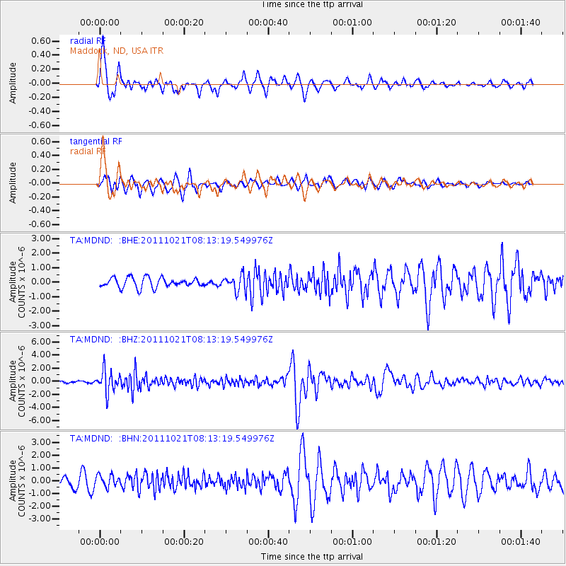
Signal To Noise
| Channel | StoN | STA | LTA |
| TA:MDND: :BHZ:20111021T08:13:19.549976Z | 12.500978 | 1.6971228E-6 | 1.357592E-7 |
| TA:MDND: :BHN:20111021T08:13:19.549976Z | 1.1225834 | 4.6816453E-7 | 4.1704212E-7 |
| TA:MDND: :BHE:20111021T08:13:19.549976Z | 1.6809287 | 5.6293084E-7 | 3.3489275E-7 |
| Arrivals |
| Ps | |
| PpPs | |
| PsPs/PpSs | |


