You are here: Home > Network List > TA - USArray Transportable Network (new EarthScope stations) Stations List
> Station 239A Gary, TX, USA > Earthquake Result Viewer
239A Gary, TX, USA - Earthquake Result Viewer
| Earthquake location: |
Hokkaido, Japan Region |
| Earthquake latitude/longitude: |
43.9/142.5 |
| Earthquake time(UTC): |
2011/10/21 (294) 08:02:37 GMT |
| Earthquake Depth: |
187 km |
| Earthquake Magnitude: |
5.9 MB, 6.1 MW, 6.1 MW |
| Earthquake Catalog/Contributor: |
WHDF/NEIC |
|
| Network: |
TA USArray Transportable Network (new EarthScope stations) |
| Station: |
239A Gary, TX, USA |
| Lat/Lon: |
32.02 N/94.47 W |
| Elevation: |
100 m |
|
| Distance: |
88.3 deg |
| Az: |
45.425 deg |
| Baz: |
322.681 deg |
| Ray Param: |
0.042254947 |
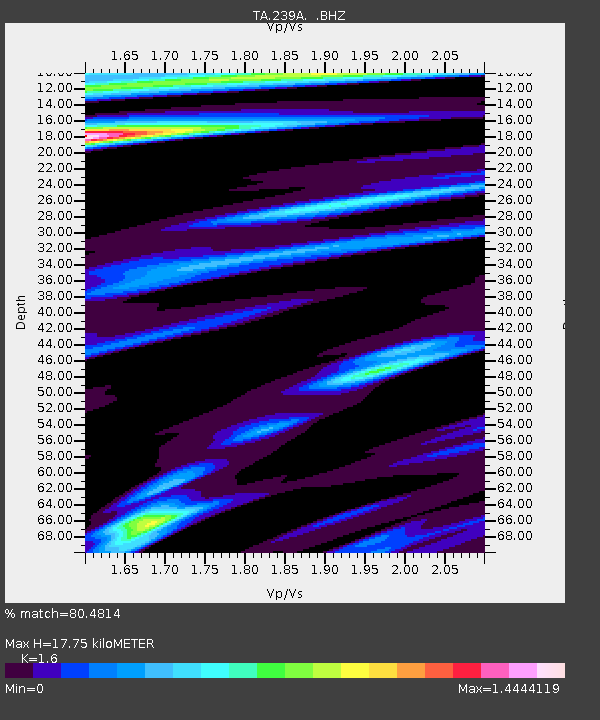
| Estimated Moho Depth: |
17.75 km |
| Estimated Crust Vp/Vs: |
1.60 |
| Assumed Crust Vp: |
6.245 km/s |
| Estimated Crust Vs: |
3.903 km/s |
| Estimated Crust Poisson's Ratio: |
0.18 |
|
| Radial Match: |
80.4814 % |
| Radial Bump: |
291 |
| Transverse Match: |
54.02204 % |
| Transverse Bump: |
387 |
| SOD ConfigId: |
424168 |
| Insert Time: |
2012-02-10 01:22:05.528 +0000 |
| GWidth: |
2.5 |
| Max Bumps: |
400 |
| Tol: |
0.001 |
|
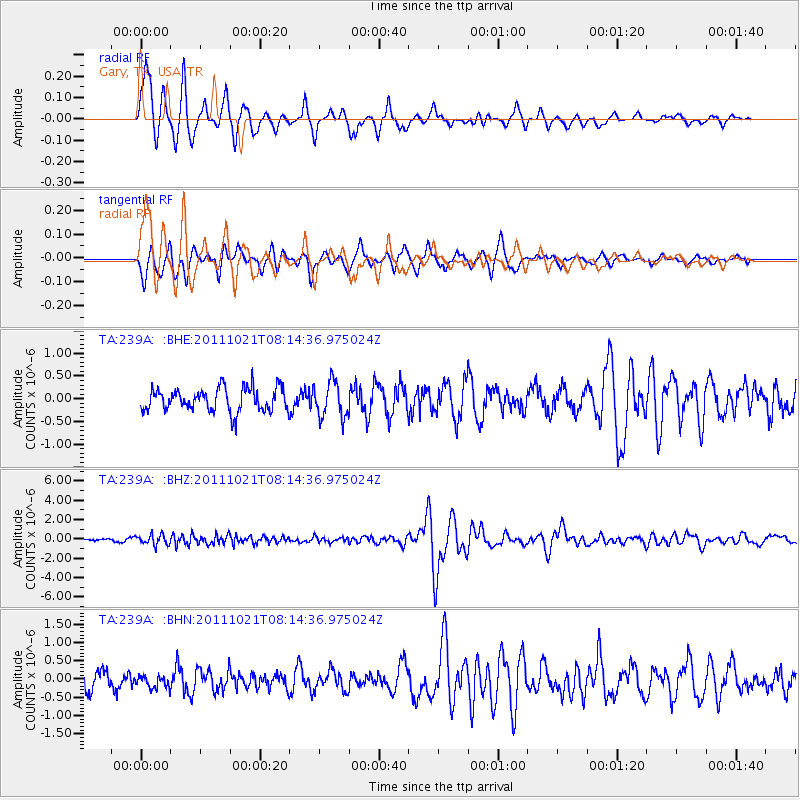
Signal To Noise
| Channel | StoN | STA | LTA |
| TA:239A: :BHZ:20111021T08:14:36.975024Z | 3.9382532 | 5.1687823E-7 | 1.3124556E-7 |
| TA:239A: :BHN:20111021T08:14:36.975024Z | 0.835562 | 1.6778482E-7 | 2.0080476E-7 |
| TA:239A: :BHE:20111021T08:14:36.975024Z | 1.5430317 | 3.9268804E-7 | 2.5449123E-7 |
| Arrivals |
| Ps | 1.7 SECOND |
| PpPs | 7.2 SECOND |
| PsPs/PpSs | 9.0 SECOND |


