You are here: Home > Network List > TA - USArray Transportable Network (new EarthScope stations) Stations List
> Station 238A Jacksonville, TX, USA > Earthquake Result Viewer
238A Jacksonville, TX, USA - Earthquake Result Viewer
| Earthquake location: |
Hokkaido, Japan Region |
| Earthquake latitude/longitude: |
43.9/142.5 |
| Earthquake time(UTC): |
2011/10/21 (294) 08:02:37 GMT |
| Earthquake Depth: |
187 km |
| Earthquake Magnitude: |
5.9 MB, 6.1 MW, 6.1 MW |
| Earthquake Catalog/Contributor: |
WHDF/NEIC |
|
| Network: |
TA USArray Transportable Network (new EarthScope stations) |
| Station: |
238A Jacksonville, TX, USA |
| Lat/Lon: |
32.00 N/95.12 W |
| Elevation: |
126 m |
|
| Distance: |
88.0 deg |
| Az: |
45.872 deg |
| Baz: |
322.353 deg |
| Ray Param: |
0.042494413 |
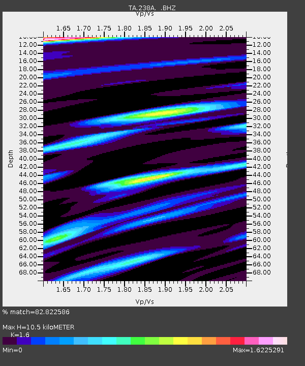
| Estimated Moho Depth: |
10.5 km |
| Estimated Crust Vp/Vs: |
1.60 |
| Assumed Crust Vp: |
6.245 km/s |
| Estimated Crust Vs: |
3.903 km/s |
| Estimated Crust Poisson's Ratio: |
0.18 |
|
| Radial Match: |
82.822586 % |
| Radial Bump: |
370 |
| Transverse Match: |
66.82442 % |
| Transverse Bump: |
321 |
| SOD ConfigId: |
424168 |
| Insert Time: |
2012-02-10 01:22:06.476 +0000 |
| GWidth: |
2.5 |
| Max Bumps: |
400 |
| Tol: |
0.001 |
|

Signal To Noise
| Channel | StoN | STA | LTA |
| TA:238A: :BHZ:20111021T08:14:35.450Z | 3.4867656 | 5.0076676E-7 | 1.4361929E-7 |
| TA:238A: :BHN:20111021T08:14:35.450Z | 0.9990441 | 1.9642665E-7 | 1.9661461E-7 |
| TA:238A: :BHE:20111021T08:14:35.450Z | 1.5259397 | 3.0777744E-7 | 2.0169699E-7 |
| Arrivals |
| Ps | 1.0 SECOND |
| PpPs | 4.3 SECOND |
| PsPs/PpSs | 5.3 SECOND |


