You are here: Home > Network List > TA - USArray Transportable Network (new EarthScope stations) Stations List
> Station R37A Teagarden Farms, La Cygne, KS, USA > Earthquake Result Viewer
R37A Teagarden Farms, La Cygne, KS, USA - Earthquake Result Viewer
| Earthquake location: |
Hokkaido, Japan Region |
| Earthquake latitude/longitude: |
43.9/142.5 |
| Earthquake time(UTC): |
2011/10/21 (294) 08:02:37 GMT |
| Earthquake Depth: |
187 km |
| Earthquake Magnitude: |
5.9 MB, 6.1 MW, 6.1 MW |
| Earthquake Catalog/Contributor: |
WHDF/NEIC |
|
| Network: |
TA USArray Transportable Network (new EarthScope stations) |
| Station: |
R37A Teagarden Farms, La Cygne, KS, USA |
| Lat/Lon: |
38.31 N/94.83 W |
| Elevation: |
298 m |
|
| Distance: |
83.1 deg |
| Az: |
41.821 deg |
| Baz: |
322.206 deg |
| Ray Param: |
0.0459442 |
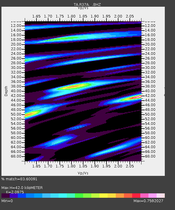
| Estimated Moho Depth: |
42.0 km |
| Estimated Crust Vp/Vs: |
2.10 |
| Assumed Crust Vp: |
6.498 km/s |
| Estimated Crust Vs: |
3.098 km/s |
| Estimated Crust Poisson's Ratio: |
0.35 |
|
| Radial Match: |
83.60091 % |
| Radial Bump: |
357 |
| Transverse Match: |
63.125126 % |
| Transverse Bump: |
400 |
| SOD ConfigId: |
424168 |
| Insert Time: |
2012-02-10 01:22:43.488 +0000 |
| GWidth: |
2.5 |
| Max Bumps: |
400 |
| Tol: |
0.001 |
|

Signal To Noise
| Channel | StoN | STA | LTA |
| TA:R37A: :BHZ:20111021T08:14:11.700Z | 4.599017 | 6.3411585E-7 | 1.3788075E-7 |
| TA:R37A: :BHN:20111021T08:14:11.700Z | 1.6352668 | 2.495713E-7 | 1.526181E-7 |
| TA:R37A: :BHE:20111021T08:14:11.700Z | 1.754144 | 2.072307E-7 | 1.1813779E-7 |
| Arrivals |
| Ps | 7.3 SECOND |
| PpPs | 20 SECOND |
| PsPs/PpSs | 27 SECOND |


