You are here: Home > Network List > TA - USArray Transportable Network (new EarthScope stations) Stations List
> Station S35A Otter Creek Ranch, Eureka, KS, USA > Earthquake Result Viewer
S35A Otter Creek Ranch, Eureka, KS, USA - Earthquake Result Viewer

| Earthquake location: |
Hokkaido, Japan Region |
| Earthquake latitude/longitude: |
43.9/142.5 |
| Earthquake time(UTC): |
2011/10/21 (294) 08:02:37 GMT |
| Earthquake Depth: |
187 km |
| Earthquake Magnitude: |
5.9 MB, 6.1 MW, 6.1 MW |
| Earthquake Catalog/Contributor: |
WHDF/NEIC |
|
| Network: |
TA USArray Transportable Network (new EarthScope stations) |
| Station: |
S35A Otter Creek Ranch, Eureka, KS, USA |
| Lat/Lon: |
37.68 N/96.32 W |
| Elevation: |
334 m |
|
| Distance: |
82.9 deg |
| Az: |
43.145 deg |
| Baz: |
321.453 deg |
| Ray Param: |
0.046107654 |
| Estimated Moho Depth: |
50.25 km |
| Estimated Crust Vp/Vs: |
1.64 |
| Assumed Crust Vp: |
6.483 km/s |
| Estimated Crust Vs: |
3.941 km/s |
| Estimated Crust Poisson's Ratio: |
0.21 |
|
| Radial Match: |
92.80817 % |
| Radial Bump: |
350 |
| Transverse Match: |
80.020645 % |
| Transverse Bump: |
400 |
| SOD ConfigId: |
424168 |
| Insert Time: |
2012-02-10 01:22:56.032 +0000 |
| GWidth: |
2.5 |
| Max Bumps: |
400 |
| Tol: |
0.001 |
|
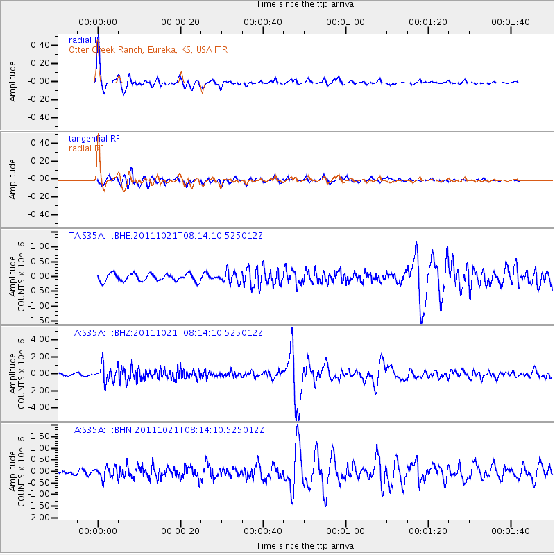
Signal To Noise
| Channel | StoN | STA | LTA |
| TA:S35A: :BHZ:20111021T08:14:10.525012Z | 6.6542187 | 9.597072E-7 | 1.4422538E-7 |
| TA:S35A: :BHN:20111021T08:14:10.525012Z | 3.2008312 | 2.4342256E-7 | 7.6049794E-8 |
| TA:S35A: :BHE:20111021T08:14:10.525012Z | 1.4913534 | 1.831723E-7 | 1.2282287E-7 |
| Arrivals |
| Ps | 5.1 SECOND |
| PpPs | 20 SECOND |
| PsPs/PpSs | 25 SECOND |


