You are here: Home > Network List > TA - USArray Transportable Network (new EarthScope stations) Stations List
> Station 236A Katherine and Luke Keathley, Corsicana, TX, USA > Earthquake Result Viewer
236A Katherine and Luke Keathley, Corsicana, TX, USA - Earthquake Result Viewer

| Earthquake location: |
Hokkaido, Japan Region |
| Earthquake latitude/longitude: |
43.9/142.5 |
| Earthquake time(UTC): |
2011/10/21 (294) 08:02:37 GMT |
| Earthquake Depth: |
187 km |
| Earthquake Magnitude: |
5.9 MB, 6.1 MW, 6.1 MW |
| Earthquake Catalog/Contributor: |
WHDF/NEIC |
|
| Network: |
TA USArray Transportable Network (new EarthScope stations) |
| Station: |
236A Katherine and Luke Keathley, Corsicana, TX, USA |
| Lat/Lon: |
32.00 N/96.53 W |
| Elevation: |
118 m |
|
| Distance: |
87.2 deg |
| Az: |
46.82 deg |
| Baz: |
321.648 deg |
| Ray Param: |
0.04303454 |
| Estimated Moho Depth: |
49.25 km |
| Estimated Crust Vp/Vs: |
1.60 |
| Assumed Crust Vp: |
6.347 km/s |
| Estimated Crust Vs: |
3.967 km/s |
| Estimated Crust Poisson's Ratio: |
0.18 |
|
| Radial Match: |
89.83829 % |
| Radial Bump: |
400 |
| Transverse Match: |
64.82066 % |
| Transverse Bump: |
400 |
| SOD ConfigId: |
424168 |
| Insert Time: |
2012-02-10 01:23:50.386 +0000 |
| GWidth: |
2.5 |
| Max Bumps: |
400 |
| Tol: |
0.001 |
|
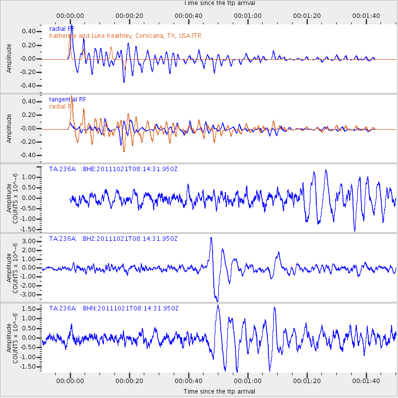
Signal To Noise
| Channel | StoN | STA | LTA |
| TA:236A: :BHZ:20111021T08:14:31.950Z | 2.3398554 | 2.1865812E-7 | 9.3449415E-8 |
| TA:236A: :BHN:20111021T08:14:31.950Z | 1.4766585 | 2.501039E-7 | 1.6937153E-7 |
| TA:236A: :BHE:20111021T08:14:31.950Z | 0.67777646 | 1.4642517E-7 | 2.1603756E-7 |
| Arrivals |
| Ps | 4.8 SECOND |
| PpPs | 20 SECOND |
| PsPs/PpSs | 24 SECOND |


