You are here: Home > Network List > TA - USArray Transportable Network (new EarthScope stations) Stations List
> Station Z39A Irene McRaven, Queen City, TX, USA > Earthquake Result Viewer
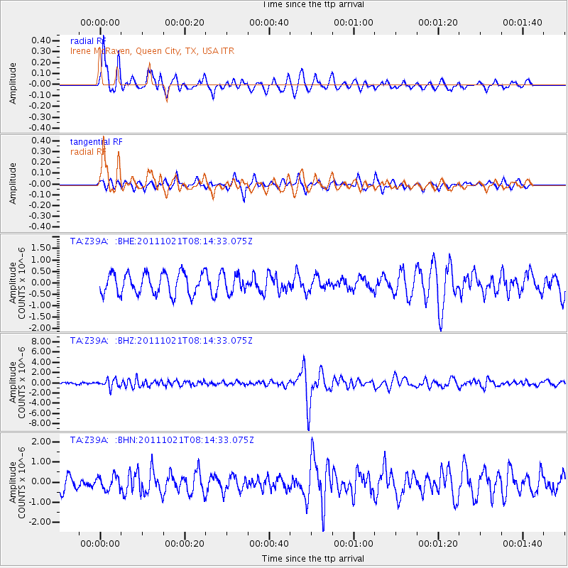
Z39A Irene McRaven, Queen City, TX, USA - Earthquake Result Viewer
*The percent match for this event was below the threshold and hence no stack was calculated.
| Earthquake location: |
Hokkaido, Japan Region |
| Earthquake latitude/longitude: |
43.9/142.5 |
| Earthquake time(UTC): |
2011/10/21 (294) 08:02:37 GMT |
| Earthquake Depth: |
187 km |
| Earthquake Magnitude: |
5.9 MB, 6.1 MW, 6.1 MW |
| Earthquake Catalog/Contributor: |
WHDF/NEIC |
|
| Network: |
TA USArray Transportable Network (new EarthScope stations) |
| Station: |
Z39A Irene McRaven, Queen City, TX, USA |
| Lat/Lon: |
33.24 N/94.18 W |
| Elevation: |
112 m |
|
| Distance: |
87.5 deg |
| Az: |
44.492 deg |
| Baz: |
322.801 deg |
| Ray Param: |
$rayparam |
*The percent match for this event was below the threshold and hence was not used in the summary stack. |
|
| Radial Match: |
77.53364 % |
| Radial Bump: |
397 |
| Transverse Match: |
55.344193 % |
| Transverse Bump: |
336 |
| SOD ConfigId: |
424168 |
| Insert Time: |
2012-02-10 01:24:06.098 +0000 |
| GWidth: |
2.5 |
| Max Bumps: |
400 |
| Tol: |
0.001 |
|
Signal To Noise
| Channel | StoN | STA | LTA |
| TA:Z39A: :BHZ:20111021T08:14:33.075Z | 3.0861104 | 8.132504E-7 | 2.6351955E-7 |
| TA:Z39A: :BHN:20111021T08:14:33.075Z | 0.8364425 | 3.4633547E-7 | 4.1405775E-7 |
| TA:Z39A: :BHE:20111021T08:14:33.075Z | 0.8295402 | 3.843656E-7 | 4.6334773E-7 |
| Arrivals |
| Ps | |
| PpPs | |
| PsPs/PpSs | |


