You are here: Home > Network List > TA - USArray Transportable Network (new EarthScope stations) Stations List
> Station Y39A Lockesburg, AR, USA > Earthquake Result Viewer
Y39A Lockesburg, AR, USA - Earthquake Result Viewer
| Earthquake location: |
Hokkaido, Japan Region |
| Earthquake latitude/longitude: |
43.9/142.5 |
| Earthquake time(UTC): |
2011/10/21 (294) 08:02:37 GMT |
| Earthquake Depth: |
187 km |
| Earthquake Magnitude: |
5.9 MB, 6.1 MW, 6.1 MW |
| Earthquake Catalog/Contributor: |
WHDF/NEIC |
|
| Network: |
TA USArray Transportable Network (new EarthScope stations) |
| Station: |
Y39A Lockesburg, AR, USA |
| Lat/Lon: |
33.94 N/94.09 W |
| Elevation: |
108 m |
|
| Distance: |
87.0 deg |
| Az: |
44.013 deg |
| Baz: |
322.827 deg |
| Ray Param: |
0.043235246 |
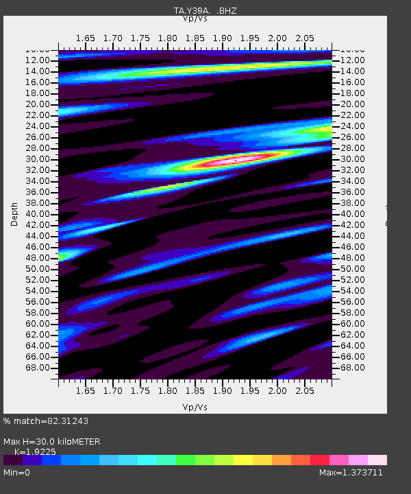
| Estimated Moho Depth: |
30.0 km |
| Estimated Crust Vp/Vs: |
1.92 |
| Assumed Crust Vp: |
6.245 km/s |
| Estimated Crust Vs: |
3.248 km/s |
| Estimated Crust Poisson's Ratio: |
0.31 |
|
| Radial Match: |
82.31243 % |
| Radial Bump: |
400 |
| Transverse Match: |
80.43458 % |
| Transverse Bump: |
400 |
| SOD ConfigId: |
424168 |
| Insert Time: |
2012-02-10 01:24:19.721 +0000 |
| GWidth: |
2.5 |
| Max Bumps: |
400 |
| Tol: |
0.001 |
|

Signal To Noise
| Channel | StoN | STA | LTA |
| TA:Y39A: :BHZ:20111021T08:14:30.650012Z | 6.1786737 | 5.4511906E-7 | 8.82259E-8 |
| TA:Y39A: :BHN:20111021T08:14:30.650012Z | 1.4053766 | 2.4239526E-7 | 1.7247709E-7 |
| TA:Y39A: :BHE:20111021T08:14:30.650012Z | 1.4179547 | 1.4430742E-7 | 1.01771526E-7 |
| Arrivals |
| Ps | 4.5 SECOND |
| PpPs | 14 SECOND |
| PsPs/PpSs | 18 SECOND |


