You are here: Home > Network List > TA - USArray Transportable Network (new EarthScope stations) Stations List
> Station Q35A Mercer Eighty, Eskridge, KS, USA > Earthquake Result Viewer
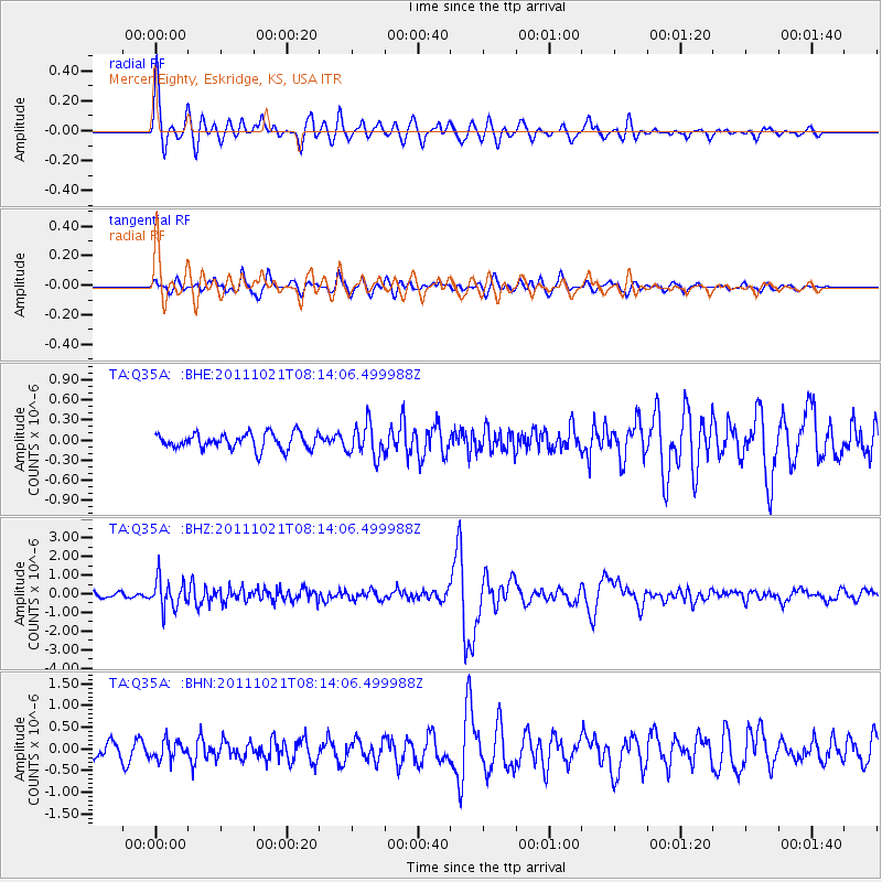
Q35A Mercer Eighty, Eskridge, KS, USA - Earthquake Result Viewer
*The percent match for this event was below the threshold and hence no stack was calculated.
| Earthquake location: |
Hokkaido, Japan Region |
| Earthquake latitude/longitude: |
43.9/142.5 |
| Earthquake time(UTC): |
2011/10/21 (294) 08:02:37 GMT |
| Earthquake Depth: |
187 km |
| Earthquake Magnitude: |
5.9 MB, 6.1 MW, 6.1 MW |
| Earthquake Catalog/Contributor: |
WHDF/NEIC |
|
| Network: |
TA USArray Transportable Network (new EarthScope stations) |
| Station: |
Q35A Mercer Eighty, Eskridge, KS, USA |
| Lat/Lon: |
38.86 N/96.04 W |
| Elevation: |
402 m |
|
| Distance: |
82.1 deg |
| Az: |
42.232 deg |
| Baz: |
321.509 deg |
| Ray Param: |
$rayparam |
*The percent match for this event was below the threshold and hence was not used in the summary stack. |
|
| Radial Match: |
78.617775 % |
| Radial Bump: |
400 |
| Transverse Match: |
74.85914 % |
| Transverse Bump: |
400 |
| SOD ConfigId: |
424168 |
| Insert Time: |
2012-02-10 01:24:56.702 +0000 |
| GWidth: |
2.5 |
| Max Bumps: |
400 |
| Tol: |
0.001 |
|
Signal To Noise
| Channel | StoN | STA | LTA |
| TA:Q35A: :BHZ:20111021T08:14:06.499988Z | 6.006187 | 7.8174577E-7 | 1.3015675E-7 |
| TA:Q35A: :BHN:20111021T08:14:06.499988Z | 0.91610944 | 2.136115E-7 | 2.3317247E-7 |
| TA:Q35A: :BHE:20111021T08:14:06.499988Z | 2.0742357 | 2.406132E-7 | 1.160009E-7 |
| Arrivals |
| Ps | |
| PpPs | |
| PsPs/PpSs | |


