You are here: Home > Network List > TA - USArray Transportable Network (new EarthScope stations) Stations List
> Station N34A Lincoln, NE, USA > Earthquake Result Viewer
N34A Lincoln, NE, USA - Earthquake Result Viewer
| Earthquake location: |
Hokkaido, Japan Region |
| Earthquake latitude/longitude: |
43.9/142.5 |
| Earthquake time(UTC): |
2011/10/21 (294) 08:02:37 GMT |
| Earthquake Depth: |
187 km |
| Earthquake Magnitude: |
5.9 MB, 6.1 MW, 6.1 MW |
| Earthquake Catalog/Contributor: |
WHDF/NEIC |
|
| Network: |
TA USArray Transportable Network (new EarthScope stations) |
| Station: |
N34A Lincoln, NE, USA |
| Lat/Lon: |
40.84 N/96.50 W |
| Elevation: |
401 m |
|
| Distance: |
80.4 deg |
| Az: |
41.263 deg |
| Baz: |
321.065 deg |
| Ray Param: |
0.04787097 |
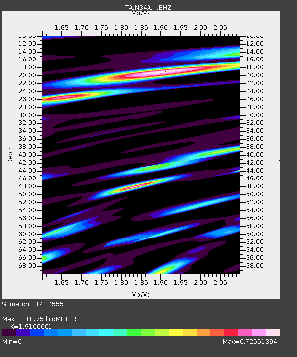
| Estimated Moho Depth: |
18.75 km |
| Estimated Crust Vp/Vs: |
1.91 |
| Assumed Crust Vp: |
6.498 km/s |
| Estimated Crust Vs: |
3.402 km/s |
| Estimated Crust Poisson's Ratio: |
0.31 |
|
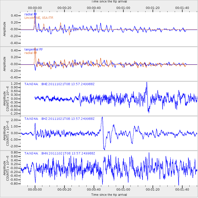
| Radial Match: |
87.12555 % |
| Radial Bump: |
400 |
| Transverse Match: |
60.573055 % |
| Transverse Bump: |
400 |
| SOD ConfigId: |
424168 |
| Insert Time: |
2012-02-10 01:25:00.957 +0000 |
| GWidth: |
2.5 |
| Max Bumps: |
400 |
| Tol: |
0.001 |
|
Signal To Noise
| Channel | StoN | STA | LTA |
| TA:N34A: :BHZ:20111021T08:13:57.249988Z | 5.0934625 | 5.3291734E-7 | 1.0462771E-7 |
| TA:N34A: :BHN:20111021T08:13:57.249988Z | 1.7697223 | 2.3327713E-7 | 1.3181567E-7 |
| TA:N34A: :BHE:20111021T08:13:57.249988Z | 2.4482102 | 2.2693791E-7 | 9.269543E-8 |
| Arrivals |
| Ps | 2.7 SECOND |
| PpPs | 8.2 SECOND |
| PsPs/PpSs | 11 SECOND |


