You are here: Home > Network List > TA - USArray Transportable Network (new EarthScope stations) Stations List
> Station U37A Salina, OK, USA > Earthquake Result Viewer
U37A Salina, OK, USA - Earthquake Result Viewer
| Earthquake location: |
Hokkaido, Japan Region |
| Earthquake latitude/longitude: |
43.9/142.5 |
| Earthquake time(UTC): |
2011/10/21 (294) 08:02:37 GMT |
| Earthquake Depth: |
187 km |
| Earthquake Magnitude: |
5.9 MB, 6.1 MW, 6.1 MW |
| Earthquake Catalog/Contributor: |
WHDF/NEIC |
|
| Network: |
TA USArray Transportable Network (new EarthScope stations) |
| Station: |
U37A Salina, OK, USA |
| Lat/Lon: |
36.41 N/95.12 W |
| Elevation: |
248 m |
|
| Distance: |
84.5 deg |
| Az: |
43.176 deg |
| Baz: |
322.178 deg |
| Ray Param: |
0.04498604 |
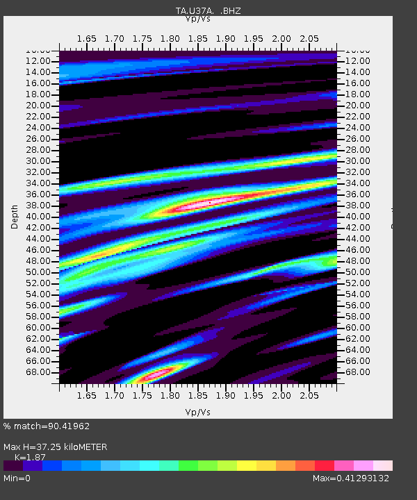
| Estimated Moho Depth: |
37.25 km |
| Estimated Crust Vp/Vs: |
1.87 |
| Assumed Crust Vp: |
6.53 km/s |
| Estimated Crust Vs: |
3.492 km/s |
| Estimated Crust Poisson's Ratio: |
0.30 |
|
| Radial Match: |
90.41962 % |
| Radial Bump: |
337 |
| Transverse Match: |
61.417824 % |
| Transverse Bump: |
400 |
| SOD ConfigId: |
424168 |
| Insert Time: |
2012-02-10 01:27:11.921 +0000 |
| GWidth: |
2.5 |
| Max Bumps: |
400 |
| Tol: |
0.001 |
|

Signal To Noise
| Channel | StoN | STA | LTA |
| TA:U37A: :BHZ:20111021T08:14:18.575Z | 2.938318 | 4.9507247E-7 | 1.684884E-7 |
| TA:U37A: :BHN:20111021T08:14:18.575Z | 1.2108933 | 1.7821361E-7 | 1.4717533E-7 |
| TA:U37A: :BHE:20111021T08:14:18.575Z | 1.483013 | 1.239813E-7 | 8.3600945E-8 |
| Arrivals |
| Ps | 5.1 SECOND |
| PpPs | 16 SECOND |
| PsPs/PpSs | 21 SECOND |


