You are here: Home > Network List > TA - USArray Transportable Network (new EarthScope stations) Stations List
> Station K33A Hardington, NE, USA > Earthquake Result Viewer
K33A Hardington, NE, USA - Earthquake Result Viewer
| Earthquake location: |
Hokkaido, Japan Region |
| Earthquake latitude/longitude: |
43.9/142.5 |
| Earthquake time(UTC): |
2011/10/21 (294) 08:02:37 GMT |
| Earthquake Depth: |
187 km |
| Earthquake Magnitude: |
5.9 MB, 6.1 MW, 6.1 MW |
| Earthquake Catalog/Contributor: |
WHDF/NEIC |
|
| Network: |
TA USArray Transportable Network (new EarthScope stations) |
| Station: |
K33A Hardington, NE, USA |
| Lat/Lon: |
42.61 N/97.00 W |
| Elevation: |
507 m |
|
| Distance: |
78.8 deg |
| Az: |
40.424 deg |
| Baz: |
320.581 deg |
| Ray Param: |
0.04895572 |
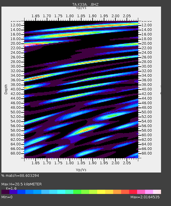
| Estimated Moho Depth: |
20.5 km |
| Estimated Crust Vp/Vs: |
1.60 |
| Assumed Crust Vp: |
6.498 km/s |
| Estimated Crust Vs: |
4.061 km/s |
| Estimated Crust Poisson's Ratio: |
0.18 |
|
| Radial Match: |
88.603294 % |
| Radial Bump: |
400 |
| Transverse Match: |
84.27589 % |
| Transverse Bump: |
400 |
| SOD ConfigId: |
424168 |
| Insert Time: |
2012-02-10 01:28:08.380 +0000 |
| GWidth: |
2.5 |
| Max Bumps: |
400 |
| Tol: |
0.001 |
|
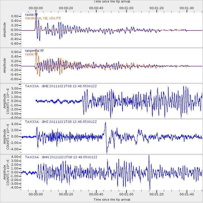
Signal To Noise
| Channel | StoN | STA | LTA |
| TA:K33A: :BHZ:20111021T08:13:48.650012Z | 9.144102 | 1.4083037E-6 | 1.5401226E-7 |
| TA:K33A: :BHN:20111021T08:13:48.650012Z | 5.3978796 | 1.048033E-6 | 1.9415641E-7 |
| TA:K33A: :BHE:20111021T08:13:48.650012Z | 7.082443 | 1.4585914E-6 | 2.0594467E-7 |
| Arrivals |
| Ps | 2.0 SECOND |
| PpPs | 7.9 SECOND |
| PsPs/PpSs | 9.9 SECOND |


