You are here: Home > Network List > G - GEOSCOPE Stations List
> Station FDF Fort de France, Martinique France > Earthquake Result Viewer
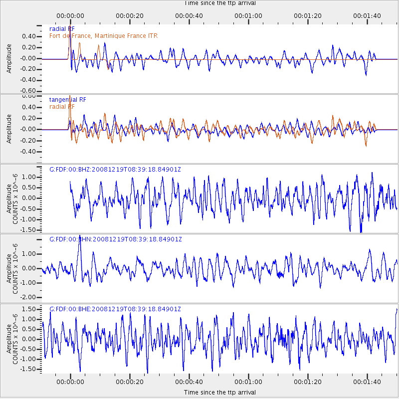
FDF Fort de France, Martinique France - Earthquake Result Viewer
*The percent match for this event was below the threshold and hence no stack was calculated.
| Earthquake location: |
Northern Mid-Atlantic Ridge |
| Earthquake latitude/longitude: |
47.0/-27.3 |
| Earthquake time(UTC): |
2008/12/19 (354) 08:31:51 GMT |
| Earthquake Depth: |
2.0 km |
| Earthquake Magnitude: |
5.8 MB, 5.6 MS, 5.9 MW, 5.8 MW |
| Earthquake Catalog/Contributor: |
WHDF/NEIC |
|
| Network: |
G GEOSCOPE |
| Station: |
FDF Fort de France, Martinique France |
| Lat/Lon: |
14.73 N/61.14 W |
| Elevation: |
467 m |
|
| Distance: |
42.8 deg |
| Az: |
232.551 deg |
| Baz: |
34.167 deg |
| Ray Param: |
$rayparam |
*The percent match for this event was below the threshold and hence was not used in the summary stack. |
|
| Radial Match: |
56.726112 % |
| Radial Bump: |
400 |
| Transverse Match: |
44.371 % |
| Transverse Bump: |
400 |
| SOD ConfigId: |
2658 |
| Insert Time: |
2010-02-26 22:34:44.058 +0000 |
| GWidth: |
2.5 |
| Max Bumps: |
400 |
| Tol: |
0.001 |
|
Signal To Noise
| Channel | StoN | STA | LTA |
| G:FDF:00:BHN:20081219T08:39:18.84901Z | 2.4104788 | 8.9017163E-7 | 3.6929245E-7 |
| G:FDF:00:BHE:20081219T08:39:18.84901Z | 1.11563 | 6.2684916E-7 | 5.6187906E-7 |
| G:FDF:00:BHZ:20081219T08:39:18.84901Z | 1.3798785 | 6.307632E-7 | 4.5711505E-7 |
| Arrivals |
| Ps | |
| PpPs | |
| PsPs/PpSs | |


