You are here: Home > Network List > TA - USArray Transportable Network (new EarthScope stations) Stations List
> Station J35A Milford, IA, USA > Earthquake Result Viewer
J35A Milford, IA, USA - Earthquake Result Viewer

| Earthquake location: |
Hokkaido, Japan Region |
| Earthquake latitude/longitude: |
43.9/142.5 |
| Earthquake time(UTC): |
2011/10/21 (294) 08:02:37 GMT |
| Earthquake Depth: |
187 km |
| Earthquake Magnitude: |
5.9 MB, 6.1 MW, 6.1 MW |
| Earthquake Catalog/Contributor: |
WHDF/NEIC |
|
| Network: |
TA USArray Transportable Network (new EarthScope stations) |
| Station: |
J35A Milford, IA, USA |
| Lat/Lon: |
43.37 N/95.21 W |
| Elevation: |
457 m |
|
| Distance: |
79.0 deg |
| Az: |
38.895 deg |
| Baz: |
321.505 deg |
| Ray Param: |
0.04879538 |
| Estimated Moho Depth: |
19.25 km |
| Estimated Crust Vp/Vs: |
1.98 |
| Assumed Crust Vp: |
6.53 km/s |
| Estimated Crust Vs: |
3.302 km/s |
| Estimated Crust Poisson's Ratio: |
0.33 |
|
| Radial Match: |
84.81203 % |
| Radial Bump: |
400 |
| Transverse Match: |
75.778625 % |
| Transverse Bump: |
400 |
| SOD ConfigId: |
424168 |
| Insert Time: |
2012-02-10 01:29:17.896 +0000 |
| GWidth: |
2.5 |
| Max Bumps: |
400 |
| Tol: |
0.001 |
|
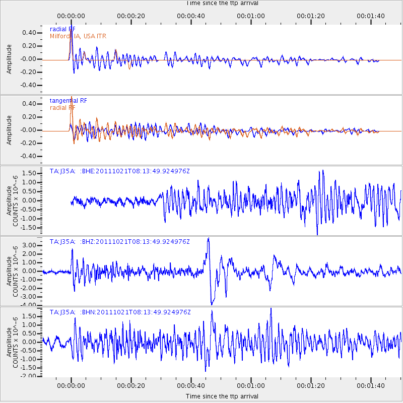
Signal To Noise
| Channel | StoN | STA | LTA |
| TA:J35A: :BHZ:20111021T08:13:49.924976Z | 6.718433 | 1.1137117E-6 | 1.6576956E-7 |
| TA:J35A: :BHN:20111021T08:13:49.924976Z | 3.41955 | 6.298555E-7 | 1.8419252E-7 |
| TA:J35A: :BHE:20111021T08:13:49.924976Z | 3.760063 | 4.950556E-7 | 1.3166152E-7 |
| Arrivals |
| Ps | 3.0 SECOND |
| PpPs | 8.5 SECOND |
| PsPs/PpSs | 12 SECOND |


