You are here: Home > Network List > TA - USArray Transportable Network (new EarthScope stations) Stations List
> Station J31A Geddes, SD, USA > Earthquake Result Viewer
J31A Geddes, SD, USA - Earthquake Result Viewer
| Earthquake location: |
Hokkaido, Japan Region |
| Earthquake latitude/longitude: |
43.9/142.5 |
| Earthquake time(UTC): |
2011/10/21 (294) 08:02:37 GMT |
| Earthquake Depth: |
187 km |
| Earthquake Magnitude: |
5.9 MB, 6.1 MW, 6.1 MW |
| Earthquake Catalog/Contributor: |
WHDF/NEIC |
|
| Network: |
TA USArray Transportable Network (new EarthScope stations) |
| Station: |
J31A Geddes, SD, USA |
| Lat/Lon: |
43.29 N/98.74 W |
| Elevation: |
491 m |
|
| Distance: |
77.4 deg |
| Az: |
40.974 deg |
| Baz: |
319.514 deg |
| Ray Param: |
0.04986145 |
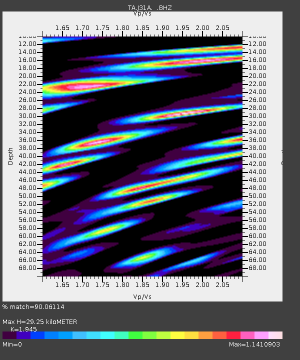
| Estimated Moho Depth: |
29.25 km |
| Estimated Crust Vp/Vs: |
1.95 |
| Assumed Crust Vp: |
6.53 km/s |
| Estimated Crust Vs: |
3.358 km/s |
| Estimated Crust Poisson's Ratio: |
0.32 |
|
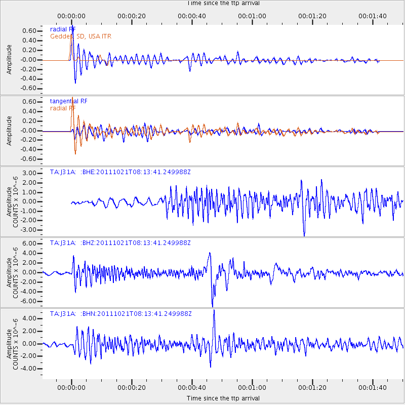
| Radial Match: |
90.06114 % |
| Radial Bump: |
400 |
| Transverse Match: |
81.86672 % |
| Transverse Bump: |
400 |
| SOD ConfigId: |
424168 |
| Insert Time: |
2012-02-10 01:29:44.238 +0000 |
| GWidth: |
2.5 |
| Max Bumps: |
400 |
| Tol: |
0.001 |
|
Signal To Noise
| Channel | StoN | STA | LTA |
| TA:J31A: :BHZ:20111021T08:13:41.249988Z | 9.331649 | 1.6570691E-6 | 1.7757517E-7 |
| TA:J31A: :BHN:20111021T08:13:41.249988Z | 6.6864543 | 1.3211264E-6 | 1.9758252E-7 |
| TA:J31A: :BHE:20111021T08:13:41.249988Z | 2.9988103 | 7.638454E-7 | 2.5471616E-7 |
| Arrivals |
| Ps | 4.4 SECOND |
| PpPs | 13 SECOND |
| PsPs/PpSs | 17 SECOND |


