You are here: Home > Network List > TA - USArray Transportable Network (new EarthScope stations) Stations List
> Station O03D Paynes Creek, CA, USA > Earthquake Result Viewer
O03D Paynes Creek, CA, USA - Earthquake Result Viewer
| Earthquake location: |
Hokkaido, Japan Region |
| Earthquake latitude/longitude: |
43.9/142.5 |
| Earthquake time(UTC): |
2011/10/21 (294) 08:02:37 GMT |
| Earthquake Depth: |
187 km |
| Earthquake Magnitude: |
5.9 MB, 6.1 MW, 6.1 MW |
| Earthquake Catalog/Contributor: |
WHDF/NEIC |
|
| Network: |
TA USArray Transportable Network (new EarthScope stations) |
| Station: |
O03D Paynes Creek, CA, USA |
| Lat/Lon: |
40.29 N/121.80 W |
| Elevation: |
968 m |
|
| Distance: |
67.0 deg |
| Az: |
55.74 deg |
| Baz: |
308.628 deg |
| Ray Param: |
0.056676127 |
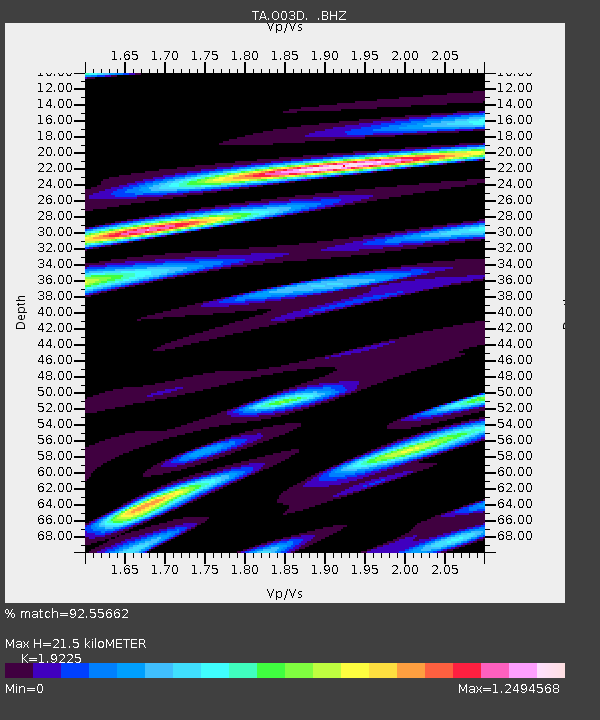
| Estimated Moho Depth: |
21.5 km |
| Estimated Crust Vp/Vs: |
1.92 |
| Assumed Crust Vp: |
6.566 km/s |
| Estimated Crust Vs: |
3.415 km/s |
| Estimated Crust Poisson's Ratio: |
0.31 |
|
| Radial Match: |
92.55662 % |
| Radial Bump: |
400 |
| Transverse Match: |
89.33744 % |
| Transverse Bump: |
400 |
| SOD ConfigId: |
424168 |
| Insert Time: |
2012-02-10 01:29:59.818 +0000 |
| GWidth: |
2.5 |
| Max Bumps: |
400 |
| Tol: |
0.001 |
|
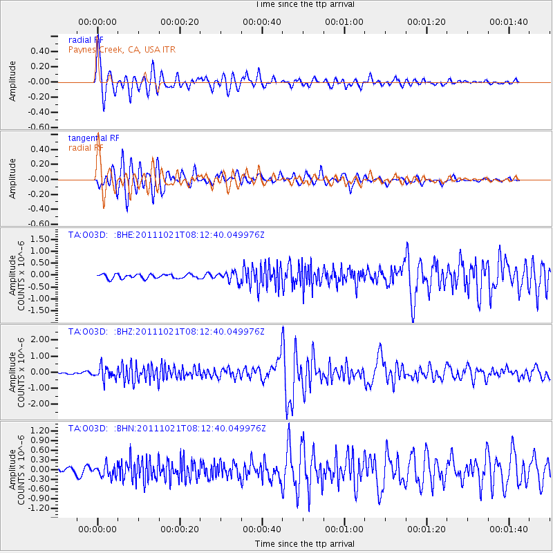
Signal To Noise
| Channel | StoN | STA | LTA |
| TA:O03D: :BHZ:20111021T08:12:40.049976Z | 7.380464 | 3.850179E-7 | 5.2167167E-8 |
| TA:O03D: :BHN:20111021T08:12:40.049976Z | 2.0054398 | 1.8533753E-7 | 9.2417395E-8 |
| TA:O03D: :BHE:20111021T08:12:40.049976Z | 2.3157878 | 2.0681613E-7 | 8.930703E-8 |
| Arrivals |
| Ps | 3.1 SECOND |
| PpPs | 9.2 SECOND |
| PsPs/PpSs | 12 SECOND |


