You are here: Home > Network List > CB - China National Seismic Network Stations List
> Station TIA Taian,Shandong Province > Earthquake Result Viewer
TIA Taian,Shandong Province - Earthquake Result Viewer
| Earthquake location: |
Solomon Islands |
| Earthquake latitude/longitude: |
-11.5/162.1 |
| Earthquake time(UTC): |
2014/04/13 (103) 12:36:18 GMT |
| Earthquake Depth: |
35 km |
| Earthquake Magnitude: |
7.4 MWW, 7.7 MI |
| Earthquake Catalog/Contributor: |
NEIC PDE/NEIC COMCAT |
|
| Network: |
CB China National Seismic Network |
| Station: |
TIA Taian,Shandong Province |
| Lat/Lon: |
36.21 N/117.12 E |
| Elevation: |
267 m |
|
| Distance: |
63.6 deg |
| Az: |
320.356 deg |
| Baz: |
129.339 deg |
| Ray Param: |
0.059435047 |
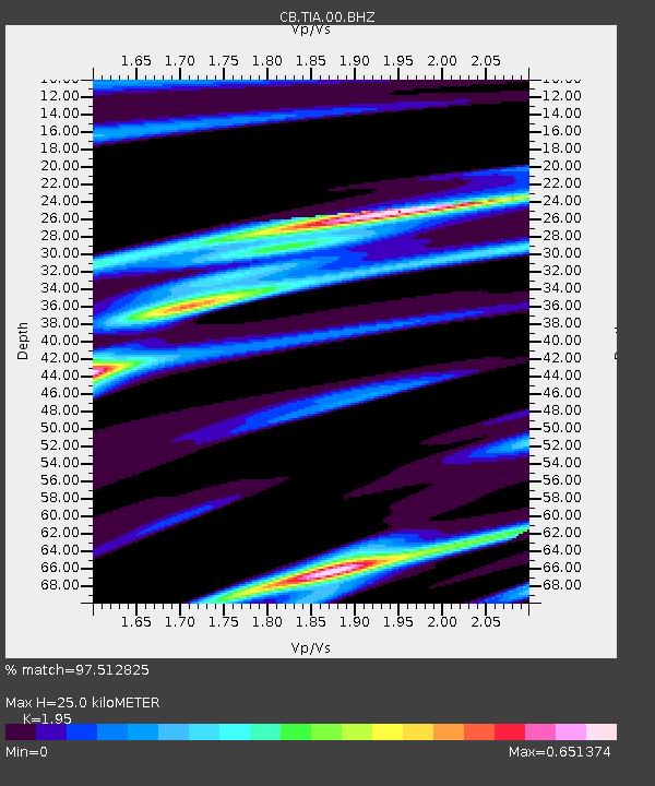
| Estimated Moho Depth: |
25.0 km |
| Estimated Crust Vp/Vs: |
1.95 |
| Assumed Crust Vp: |
6.363 km/s |
| Estimated Crust Vs: |
3.263 km/s |
| Estimated Crust Poisson's Ratio: |
0.32 |
|
| Radial Match: |
97.512825 % |
| Radial Bump: |
213 |
| Transverse Match: |
84.18901 % |
| Transverse Bump: |
400 |
| SOD ConfigId: |
3390531 |
| Insert Time: |
2019-04-11 09:06:53.229 +0000 |
| GWidth: |
2.5 |
| Max Bumps: |
400 |
| Tol: |
0.001 |
|

Signal To Noise
| Channel | StoN | STA | LTA |
| CB:TIA:00:BHZ:20140413T12:46:15.069985Z | 89.08482 | 1.1455286E-5 | 1.2858852E-7 |
| CB:TIA:00:BHN:20140413T12:46:15.069985Z | 34.401974 | 3.902638E-6 | 1.1344227E-7 |
| CB:TIA:00:BHE:20140413T12:46:15.069985Z | 41.501743 | 4.5230836E-6 | 1.0898538E-7 |
| Arrivals |
| Ps | 3.9 SECOND |
| PpPs | 11 SECOND |
| PsPs/PpSs | 15 SECOND |


