You are here: Home > Network List > TA - USArray Transportable Network (new EarthScope stations) Stations List
> Station G34A Benson, MN, USA > Earthquake Result Viewer
G34A Benson, MN, USA - Earthquake Result Viewer

| Earthquake location: |
Hokkaido, Japan Region |
| Earthquake latitude/longitude: |
43.9/142.5 |
| Earthquake time(UTC): |
2011/10/21 (294) 08:02:37 GMT |
| Earthquake Depth: |
187 km |
| Earthquake Magnitude: |
5.9 MB, 6.1 MW, 6.1 MW |
| Earthquake Catalog/Contributor: |
WHDF/NEIC |
|
| Network: |
TA USArray Transportable Network (new EarthScope stations) |
| Station: |
G34A Benson, MN, USA |
| Lat/Lon: |
45.24 N/95.64 W |
| Elevation: |
316 m |
|
| Distance: |
77.3 deg |
| Az: |
37.941 deg |
| Baz: |
321.01 deg |
| Ray Param: |
0.049911685 |
| Estimated Moho Depth: |
15.75 km |
| Estimated Crust Vp/Vs: |
1.84 |
| Assumed Crust Vp: |
6.571 km/s |
| Estimated Crust Vs: |
3.566 km/s |
| Estimated Crust Poisson's Ratio: |
0.29 |
|
| Radial Match: |
83.204445 % |
| Radial Bump: |
400 |
| Transverse Match: |
64.90284 % |
| Transverse Bump: |
400 |
| SOD ConfigId: |
424168 |
| Insert Time: |
2012-02-10 01:34:11.276 +0000 |
| GWidth: |
2.5 |
| Max Bumps: |
400 |
| Tol: |
0.001 |
|
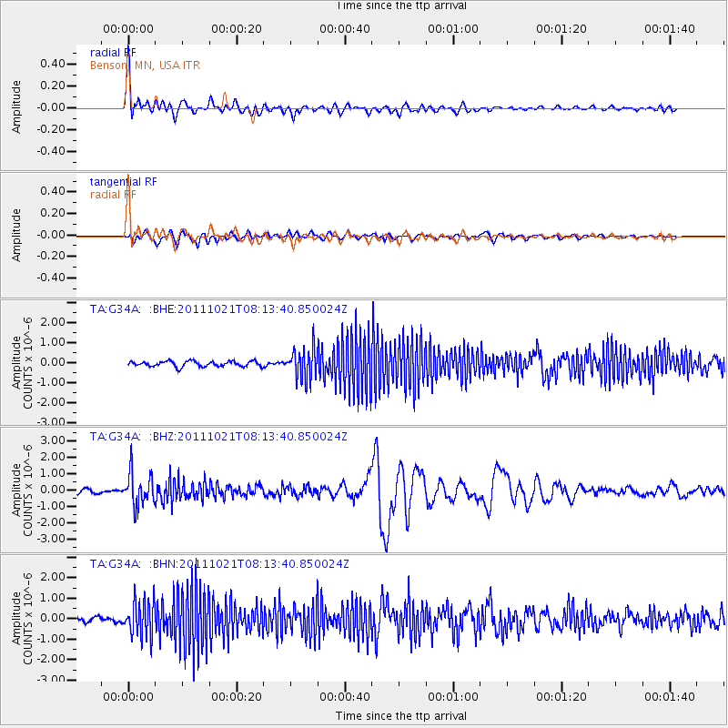
Signal To Noise
| Channel | StoN | STA | LTA |
| TA:G34A: :BHZ:20111021T08:13:40.850024Z | 6.5559435 | 1.0217176E-6 | 1.5584602E-7 |
| TA:G34A: :BHN:20111021T08:13:40.850024Z | 9.018347 | 8.5984925E-7 | 9.534444E-8 |
| TA:G34A: :BHE:20111021T08:13:40.850024Z | 5.692723 | 7.584025E-7 | 1.3322315E-7 |
| Arrivals |
| Ps | 2.1 SECOND |
| PpPs | 6.6 SECOND |
| PsPs/PpSs | 8.7 SECOND |


