You are here: Home > Network List > JP - Japan Meteorological Agency Seismic Network Stations List
> Station JCJ Chichijima Island > Earthquake Result Viewer
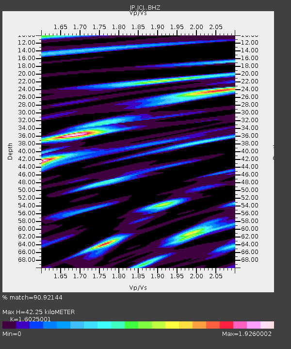
JCJ Chichijima Island - Earthquake Result Viewer
| Earthquake location: |
Solomon Islands |
| Earthquake latitude/longitude: |
-11.5/162.1 |
| Earthquake time(UTC): |
2014/04/13 (103) 12:36:18 GMT |
| Earthquake Depth: |
35 km |
| Earthquake Magnitude: |
7.4 MWW, 7.7 MI |
| Earthquake Catalog/Contributor: |
NEIC PDE/NEIC COMCAT |
|
| Network: |
JP Japan Meteorological Agency Seismic Network |
| Station: |
JCJ Chichijima Island |
| Lat/Lon: |
27.10 N/142.18 E |
| Elevation: |
150 m |
|
| Distance: |
42.9 deg |
| Az: |
333.551 deg |
| Baz: |
150.672 deg |
| Ray Param: |
0.07282023 |
| Estimated Moho Depth: |
42.25 km |
| Estimated Crust Vp/Vs: |
1.60 |
| Assumed Crust Vp: |
4.24 km/s |
| Estimated Crust Vs: |
2.646 km/s |
| Estimated Crust Poisson's Ratio: |
0.18 |
|
| Radial Match: |
90.92144 % |
| Radial Bump: |
400 |
| Transverse Match: |
84.53942 % |
| Transverse Bump: |
400 |
| SOD ConfigId: |
3390531 |
| Insert Time: |
2019-04-11 09:07:58.571 +0000 |
| GWidth: |
2.5 |
| Max Bumps: |
400 |
| Tol: |
0.001 |
|

Signal To Noise
| Channel | StoN | STA | LTA |
| JP:JCJ: :BHZ:20140413T12:43:43.600015Z | 6.828586 | 6.8452614E-6 | 1.002442E-6 |
| JP:JCJ: :BHN:20140413T12:43:43.600015Z | 4.4571023 | 3.9174984E-6 | 8.789339E-7 |
| JP:JCJ: :BHE:20140413T12:43:43.600015Z | 2.2215223 | 2.3157343E-6 | 1.0424087E-6 |
| Arrivals |
| Ps | 6.2 SECOND |
| PpPs | 25 SECOND |
| PsPs/PpSs | 31 SECOND |


