You are here: Home > Network List > KN - Kyrgyz Seismic Telemetry Network Stations List
> Station UCH - > Earthquake Result Viewer
UCH - - Earthquake Result Viewer
| Earthquake location: |
Solomon Islands |
| Earthquake latitude/longitude: |
-11.5/162.1 |
| Earthquake time(UTC): |
2014/04/13 (103) 12:36:18 GMT |
| Earthquake Depth: |
35 km |
| Earthquake Magnitude: |
7.4 MWW, 7.7 MI |
| Earthquake Catalog/Contributor: |
NEIC PDE/NEIC COMCAT |
|
| Network: |
KN Kyrgyz Seismic Telemetry Network |
| Station: |
UCH - |
| Lat/Lon: |
42.23 N/74.51 E |
| Elevation: |
3850 m |
|
| Distance: |
95.8 deg |
| Az: |
311.767 deg |
| Baz: |
100.102 deg |
| Ray Param: |
0.040670905 |
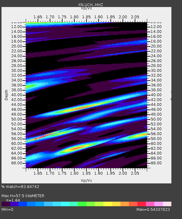
| Estimated Moho Depth: |
57.5 km |
| Estimated Crust Vp/Vs: |
1.64 |
| Assumed Crust Vp: |
6.306 km/s |
| Estimated Crust Vs: |
3.845 km/s |
| Estimated Crust Poisson's Ratio: |
0.20 |
|
| Radial Match: |
93.64742 % |
| Radial Bump: |
354 |
| Transverse Match: |
86.49682 % |
| Transverse Bump: |
400 |
| SOD ConfigId: |
3390531 |
| Insert Time: |
2019-04-11 09:08:08.858 +0000 |
| GWidth: |
2.5 |
| Max Bumps: |
400 |
| Tol: |
0.001 |
|
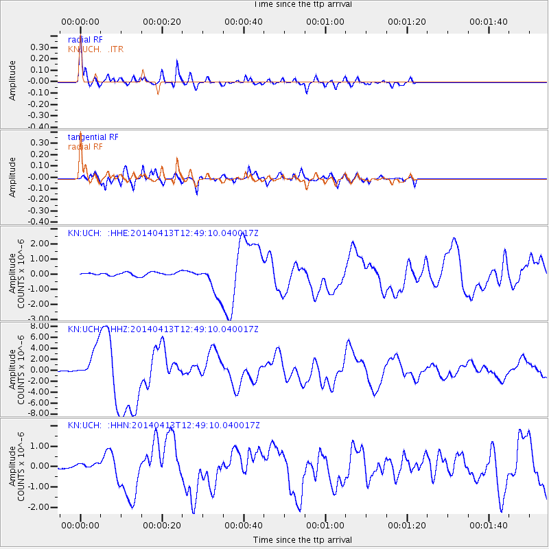
Signal To Noise
| Channel | StoN | STA | LTA |
| KN:UCH: :HHZ:20140413T12:49:10.040017Z | 19.850847 | 3.115232E-6 | 1.5693195E-7 |
| KN:UCH: :HHN:20140413T12:49:10.040017Z | 0.688912 | 1.2222918E-7 | 1.7742352E-7 |
| KN:UCH: :HHE:20140413T12:49:10.040017Z | 9.621469 | 1.0370201E-6 | 1.07781894E-7 |
| Arrivals |
| Ps | 6.0 SECOND |
| PpPs | 24 SECOND |
| PsPs/PpSs | 30 SECOND |


