You are here: Home > Network List > TA - USArray Transportable Network (new EarthScope stations) Stations List
> Station E36A McGregor, MN, USA > Earthquake Result Viewer
E36A McGregor, MN, USA - Earthquake Result Viewer
| Earthquake location: |
Hokkaido, Japan Region |
| Earthquake latitude/longitude: |
43.9/142.5 |
| Earthquake time(UTC): |
2011/10/21 (294) 08:02:37 GMT |
| Earthquake Depth: |
187 km |
| Earthquake Magnitude: |
5.9 MB, 6.1 MW, 6.1 MW |
| Earthquake Catalog/Contributor: |
WHDF/NEIC |
|
| Network: |
TA USArray Transportable Network (new EarthScope stations) |
| Station: |
E36A McGregor, MN, USA |
| Lat/Lon: |
46.52 N/93.26 W |
| Elevation: |
393 m |
|
| Distance: |
77.4 deg |
| Az: |
35.793 deg |
| Baz: |
322.244 deg |
| Ray Param: |
0.049889535 |
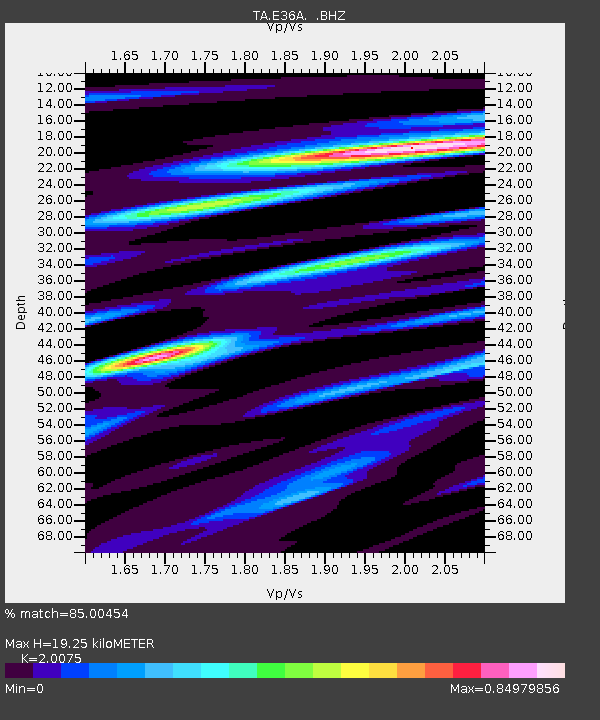
| Estimated Moho Depth: |
19.25 km |
| Estimated Crust Vp/Vs: |
2.01 |
| Assumed Crust Vp: |
6.571 km/s |
| Estimated Crust Vs: |
3.273 km/s |
| Estimated Crust Poisson's Ratio: |
0.33 |
|
| Radial Match: |
85.00454 % |
| Radial Bump: |
400 |
| Transverse Match: |
66.75405 % |
| Transverse Bump: |
400 |
| SOD ConfigId: |
424168 |
| Insert Time: |
2012-02-10 01:36:30.286 +0000 |
| GWidth: |
2.5 |
| Max Bumps: |
400 |
| Tol: |
0.001 |
|
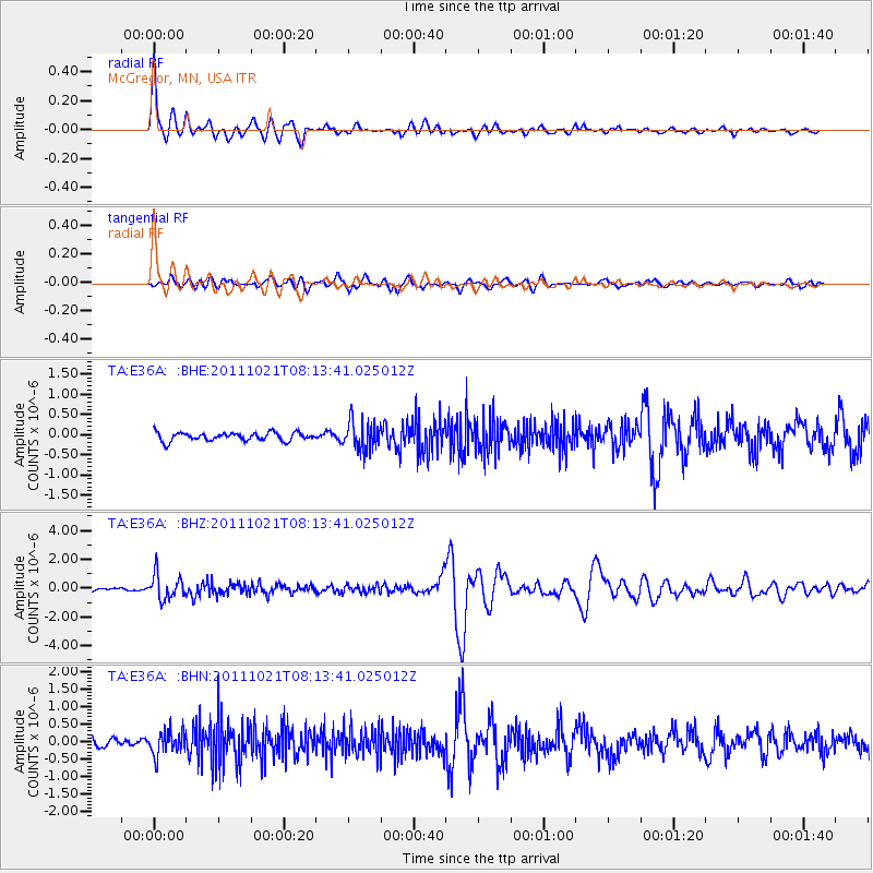
Signal To Noise
| Channel | StoN | STA | LTA |
| TA:E36A: :BHZ:20111021T08:13:41.025012Z | 6.1752925 | 8.7087636E-7 | 1.4102594E-7 |
| TA:E36A: :BHN:20111021T08:13:41.025012Z | 1.9665656 | 3.3378683E-7 | 1.6973084E-7 |
| TA:E36A: :BHE:20111021T08:13:41.025012Z | 3.5438926 | 3.565534E-7 | 1.0061066E-7 |
| Arrivals |
| Ps | 3.0 SECOND |
| PpPs | 8.6 SECOND |
| PsPs/PpSs | 12 SECOND |


