You are here: Home > Network List > TA - USArray Transportable Network (new EarthScope stations) Stations List
> Station N39A Derby Farms, Drakesville, IA, USA > Earthquake Result Viewer
N39A Derby Farms, Drakesville, IA, USA - Earthquake Result Viewer

| Earthquake location: |
Hokkaido, Japan Region |
| Earthquake latitude/longitude: |
43.9/142.5 |
| Earthquake time(UTC): |
2011/10/21 (294) 08:02:37 GMT |
| Earthquake Depth: |
187 km |
| Earthquake Magnitude: |
5.9 MB, 6.1 MW, 6.1 MW |
| Earthquake Catalog/Contributor: |
WHDF/NEIC |
|
| Network: |
TA USArray Transportable Network (new EarthScope stations) |
| Station: |
N39A Derby Farms, Drakesville, IA, USA |
| Lat/Lon: |
40.88 N/92.50 W |
| Elevation: |
260 m |
|
| Distance: |
82.2 deg |
| Az: |
38.815 deg |
| Baz: |
323.3 deg |
| Ray Param: |
0.046607297 |
| Estimated Moho Depth: |
32.0 km |
| Estimated Crust Vp/Vs: |
2.10 |
| Assumed Crust Vp: |
6.498 km/s |
| Estimated Crust Vs: |
3.101 km/s |
| Estimated Crust Poisson's Ratio: |
0.35 |
|
| Radial Match: |
84.14053 % |
| Radial Bump: |
354 |
| Transverse Match: |
65.0302 % |
| Transverse Bump: |
400 |
| SOD ConfigId: |
424168 |
| Insert Time: |
2012-02-10 01:38:40.117 +0000 |
| GWidth: |
2.5 |
| Max Bumps: |
400 |
| Tol: |
0.001 |
|
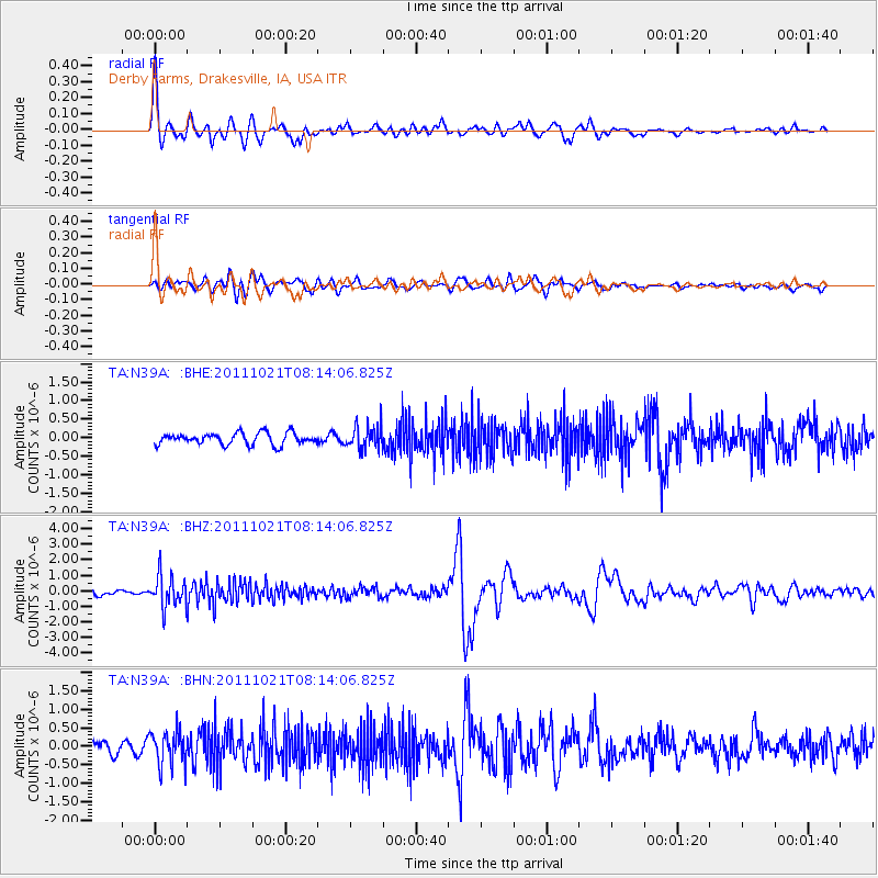
Signal To Noise
| Channel | StoN | STA | LTA |
| TA:N39A: :BHZ:20111021T08:14:06.825Z | 4.737089 | 9.947368E-7 | 2.0998904E-7 |
| TA:N39A: :BHN:20111021T08:14:06.825Z | 3.184622 | 4.5937938E-7 | 1.4424927E-7 |
| TA:N39A: :BHE:20111021T08:14:06.825Z | 2.051563 | 3.2335535E-7 | 1.5761414E-7 |
| Arrivals |
| Ps | 5.5 SECOND |
| PpPs | 15 SECOND |
| PsPs/PpSs | 20 SECOND |


