You are here: Home > Network List > TA - USArray Transportable Network (new EarthScope stations) Stations List
> Station Q39A Willow Grove Farm, Nelson, MO, USA > Earthquake Result Viewer
Q39A Willow Grove Farm, Nelson, MO, USA - Earthquake Result Viewer
| Earthquake location: |
Hokkaido, Japan Region |
| Earthquake latitude/longitude: |
43.9/142.5 |
| Earthquake time(UTC): |
2011/10/21 (294) 08:02:37 GMT |
| Earthquake Depth: |
187 km |
| Earthquake Magnitude: |
5.9 MB, 6.1 MW, 6.1 MW |
| Earthquake Catalog/Contributor: |
WHDF/NEIC |
|
| Network: |
TA USArray Transportable Network (new EarthScope stations) |
| Station: |
Q39A Willow Grove Farm, Nelson, MO, USA |
| Lat/Lon: |
39.05 N/92.98 W |
| Elevation: |
225 m |
|
| Distance: |
83.4 deg |
| Az: |
40.213 deg |
| Baz: |
323.172 deg |
| Ray Param: |
0.0457363 |
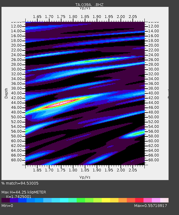
| Estimated Moho Depth: |
44.25 km |
| Estimated Crust Vp/Vs: |
1.74 |
| Assumed Crust Vp: |
6.498 km/s |
| Estimated Crust Vs: |
3.729 km/s |
| Estimated Crust Poisson's Ratio: |
0.25 |
|
| Radial Match: |
94.53005 % |
| Radial Bump: |
400 |
| Transverse Match: |
67.864395 % |
| Transverse Bump: |
400 |
| SOD ConfigId: |
424168 |
| Insert Time: |
2012-02-10 01:39:06.097 +0000 |
| GWidth: |
2.5 |
| Max Bumps: |
400 |
| Tol: |
0.001 |
|

Signal To Noise
| Channel | StoN | STA | LTA |
| TA:Q39A: :BHZ:20111021T08:14:13.225024Z | 4.9140906 | 9.907569E-7 | 2.016155E-7 |
| TA:Q39A: :BHN:20111021T08:14:13.225024Z | 2.237205 | 2.4866355E-7 | 1.1114919E-7 |
| TA:Q39A: :BHE:20111021T08:14:13.225024Z | 2.312252 | 2.9521354E-7 | 1.276736E-7 |
| Arrivals |
| Ps | 5.2 SECOND |
| PpPs | 18 SECOND |
| PsPs/PpSs | 23 SECOND |


