You are here: Home > Network List > TA - USArray Transportable Network (new EarthScope stations) Stations List
> Station T39A Clever, MO, USA > Earthquake Result Viewer
T39A Clever, MO, USA - Earthquake Result Viewer
| Earthquake location: |
Hokkaido, Japan Region |
| Earthquake latitude/longitude: |
43.9/142.5 |
| Earthquake time(UTC): |
2011/10/21 (294) 08:02:37 GMT |
| Earthquake Depth: |
187 km |
| Earthquake Magnitude: |
5.9 MB, 6.1 MW, 6.1 MW |
| Earthquake Catalog/Contributor: |
WHDF/NEIC |
|
| Network: |
TA USArray Transportable Network (new EarthScope stations) |
| Station: |
T39A Clever, MO, USA |
| Lat/Lon: |
37.02 N/93.38 W |
| Elevation: |
366 m |
|
| Distance: |
84.9 deg |
| Az: |
41.685 deg |
| Baz: |
323.075 deg |
| Ray Param: |
0.044731822 |
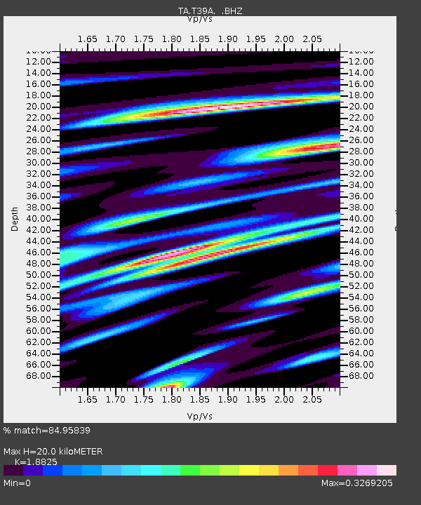
| Estimated Moho Depth: |
20.0 km |
| Estimated Crust Vp/Vs: |
1.88 |
| Assumed Crust Vp: |
6.53 km/s |
| Estimated Crust Vs: |
3.469 km/s |
| Estimated Crust Poisson's Ratio: |
0.30 |
|
| Radial Match: |
84.95839 % |
| Radial Bump: |
309 |
| Transverse Match: |
55.206795 % |
| Transverse Bump: |
400 |
| SOD ConfigId: |
424168 |
| Insert Time: |
2012-02-10 01:40:19.870 +0000 |
| GWidth: |
2.5 |
| Max Bumps: |
400 |
| Tol: |
0.001 |
|

Signal To Noise
| Channel | StoN | STA | LTA |
| TA:T39A: :BHZ:20111021T08:14:20.374988Z | 3.08496 | 4.0570887E-7 | 1.3151188E-7 |
| TA:T39A: :BHN:20111021T08:14:20.374988Z | 2.588995 | 2.2164137E-7 | 8.560904E-8 |
| TA:T39A: :BHE:20111021T08:14:20.374988Z | 0.613215 | 7.681169E-8 | 1.252606E-7 |
| Arrivals |
| Ps | 2.8 SECOND |
| PpPs | 8.6 SECOND |
| PsPs/PpSs | 11 SECOND |


