You are here: Home > Network List > TA - USArray Transportable Network (new EarthScope stations) Stations List
> Station T38A Diamond, MO, USA > Earthquake Result Viewer
T38A Diamond, MO, USA - Earthquake Result Viewer
| Earthquake location: |
Hokkaido, Japan Region |
| Earthquake latitude/longitude: |
43.9/142.5 |
| Earthquake time(UTC): |
2011/10/21 (294) 08:02:37 GMT |
| Earthquake Depth: |
187 km |
| Earthquake Magnitude: |
5.9 MB, 6.1 MW, 6.1 MW |
| Earthquake Catalog/Contributor: |
WHDF/NEIC |
|
| Network: |
TA USArray Transportable Network (new EarthScope stations) |
| Station: |
T38A Diamond, MO, USA |
| Lat/Lon: |
37.04 N/94.29 W |
| Elevation: |
349 m |
|
| Distance: |
84.4 deg |
| Az: |
42.265 deg |
| Baz: |
322.58 deg |
| Ray Param: |
0.045052756 |
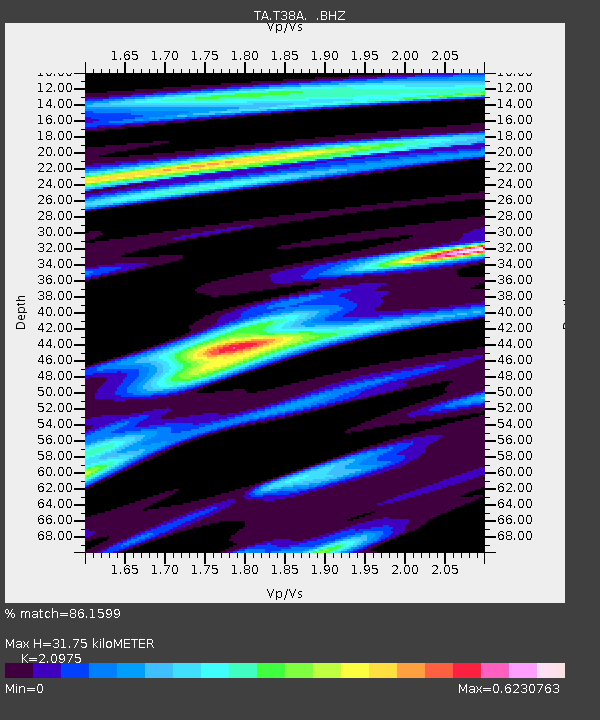
| Estimated Moho Depth: |
31.75 km |
| Estimated Crust Vp/Vs: |
2.10 |
| Assumed Crust Vp: |
6.53 km/s |
| Estimated Crust Vs: |
3.113 km/s |
| Estimated Crust Poisson's Ratio: |
0.35 |
|
| Radial Match: |
86.1599 % |
| Radial Bump: |
388 |
| Transverse Match: |
66.06188 % |
| Transverse Bump: |
400 |
| SOD ConfigId: |
424168 |
| Insert Time: |
2012-02-10 01:40:55.720 +0000 |
| GWidth: |
2.5 |
| Max Bumps: |
400 |
| Tol: |
0.001 |
|

Signal To Noise
| Channel | StoN | STA | LTA |
| TA:T38A: :BHZ:20111021T08:14:18.124988Z | 6.0542636 | 7.276699E-7 | 1.2019132E-7 |
| TA:T38A: :BHN:20111021T08:14:18.124988Z | 1.7553948 | 2.4959775E-7 | 1.4218894E-7 |
| TA:T38A: :BHE:20111021T08:14:18.124988Z | 2.126346 | 1.7526271E-7 | 8.242436E-8 |
| Arrivals |
| Ps | 5.5 SECOND |
| PpPs | 15 SECOND |
| PsPs/PpSs | 20 SECOND |


