You are here: Home > Network List > TA - USArray Transportable Network (new EarthScope stations) Stations List
> Station U40A Yellville, AR, USA > Earthquake Result Viewer
U40A Yellville, AR, USA - Earthquake Result Viewer

| Earthquake location: |
Hokkaido, Japan Region |
| Earthquake latitude/longitude: |
43.9/142.5 |
| Earthquake time(UTC): |
2011/10/21 (294) 08:02:37 GMT |
| Earthquake Depth: |
187 km |
| Earthquake Magnitude: |
5.9 MB, 6.1 MW, 6.1 MW |
| Earthquake Catalog/Contributor: |
WHDF/NEIC |
|
| Network: |
TA USArray Transportable Network (new EarthScope stations) |
| Station: |
U40A Yellville, AR, USA |
| Lat/Lon: |
36.36 N/92.85 W |
| Elevation: |
374 m |
|
| Distance: |
85.7 deg |
| Az: |
41.747 deg |
| Baz: |
323.392 deg |
| Ray Param: |
0.044177964 |
| Estimated Moho Depth: |
27.25 km |
| Estimated Crust Vp/Vs: |
2.02 |
| Assumed Crust Vp: |
6.53 km/s |
| Estimated Crust Vs: |
3.237 km/s |
| Estimated Crust Poisson's Ratio: |
0.34 |
|
| Radial Match: |
90.519424 % |
| Radial Bump: |
340 |
| Transverse Match: |
72.34013 % |
| Transverse Bump: |
400 |
| SOD ConfigId: |
424168 |
| Insert Time: |
2012-02-10 01:41:08.975 +0000 |
| GWidth: |
2.5 |
| Max Bumps: |
400 |
| Tol: |
0.001 |
|
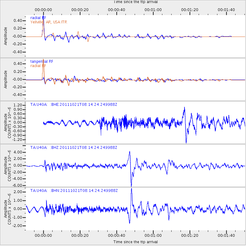
Signal To Noise
| Channel | StoN | STA | LTA |
| TA:U40A: :BHZ:20111021T08:14:24.249988Z | 6.0539007 | 6.517537E-7 | 1.0765847E-7 |
| TA:U40A: :BHN:20111021T08:14:24.249988Z | 2.5652053 | 3.4427177E-7 | 1.3420826E-7 |
| TA:U40A: :BHE:20111021T08:14:24.249988Z | 2.2586267 | 2.1687704E-7 | 9.602164E-8 |
| Arrivals |
| Ps | 4.3 SECOND |
| PpPs | 12 SECOND |
| PsPs/PpSs | 17 SECOND |


