You are here: Home > Network List > G - GEOSCOPE Stations List
> Station FOMA Nahampoana reservation, Fort Dauphin, Madagascar > Earthquake Result Viewer
FOMA Nahampoana reservation, Fort Dauphin, Madagascar - Earthquake Result Viewer
| Earthquake location: |
Banda Sea |
| Earthquake latitude/longitude: |
-7.1/123.4 |
| Earthquake time(UTC): |
2009/08/28 (240) 01:51:20 GMT |
| Earthquake Depth: |
642 km |
| Earthquake Magnitude: |
6.3 MB, 6.9 MW, 6.9 MW |
| Earthquake Catalog/Contributor: |
WHDF/NEIC |
|
| Network: |
G GEOSCOPE |
| Station: |
FOMA Nahampoana reservation, Fort Dauphin, Madagascar |
| Lat/Lon: |
24.98 S/46.98 E |
| Elevation: |
26 m |
|
| Distance: |
74.8 deg |
| Az: |
246.131 deg |
| Baz: |
90.862 deg |
| Ray Param: |
0.049968474 |
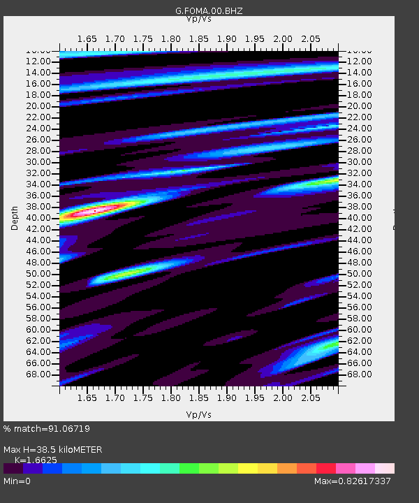
| Estimated Moho Depth: |
38.5 km |
| Estimated Crust Vp/Vs: |
1.66 |
| Assumed Crust Vp: |
6.183 km/s |
| Estimated Crust Vs: |
3.719 km/s |
| Estimated Crust Poisson's Ratio: |
0.22 |
|
| Radial Match: |
91.06719 % |
| Radial Bump: |
400 |
| Transverse Match: |
73.57431 % |
| Transverse Bump: |
400 |
| SOD ConfigId: |
2622 |
| Insert Time: |
2010-02-26 22:35:12.493 +0000 |
| GWidth: |
2.5 |
| Max Bumps: |
400 |
| Tol: |
0.001 |
|

Signal To Noise
| Channel | StoN | STA | LTA |
| G:FOMA:00:BHZ:20090828T02:01:25.748999Z | 6.17647 | 3.221472E-6 | 5.2157174E-7 |
| G:FOMA:00:BHN:20090828T02:01:25.748999Z | 1.4382564 | 4.9850837E-7 | 3.4660604E-7 |
| G:FOMA:00:BHE:20090828T02:01:25.748999Z | 3.1985304 | 1.18421E-6 | 3.7023565E-7 |
| Arrivals |
| Ps | 4.2 SECOND |
| PpPs | 16 SECOND |
| PsPs/PpSs | 20 SECOND |


