You are here: Home > Network List > TA - USArray Transportable Network (new EarthScope stations) Stations List
> Station W37B Quinton, OK, USA > Earthquake Result Viewer
W37B Quinton, OK, USA - Earthquake Result Viewer

| Earthquake location: |
Hokkaido, Japan Region |
| Earthquake latitude/longitude: |
43.9/142.5 |
| Earthquake time(UTC): |
2011/10/21 (294) 08:02:37 GMT |
| Earthquake Depth: |
187 km |
| Earthquake Magnitude: |
5.9 MB, 6.1 MW, 6.1 MW |
| Earthquake Catalog/Contributor: |
WHDF/NEIC |
|
| Network: |
TA USArray Transportable Network (new EarthScope stations) |
| Station: |
W37B Quinton, OK, USA |
| Lat/Lon: |
35.14 N/95.43 W |
| Elevation: |
279 m |
|
| Distance: |
85.3 deg |
| Az: |
44.159 deg |
| Baz: |
322.082 deg |
| Ray Param: |
0.04439074 |
| Estimated Moho Depth: |
19.25 km |
| Estimated Crust Vp/Vs: |
1.60 |
| Assumed Crust Vp: |
6.498 km/s |
| Estimated Crust Vs: |
4.061 km/s |
| Estimated Crust Poisson's Ratio: |
0.18 |
|
| Radial Match: |
86.01046 % |
| Radial Bump: |
400 |
| Transverse Match: |
75.32762 % |
| Transverse Bump: |
381 |
| SOD ConfigId: |
424168 |
| Insert Time: |
2012-02-10 01:41:16.370 +0000 |
| GWidth: |
2.5 |
| Max Bumps: |
400 |
| Tol: |
0.001 |
|
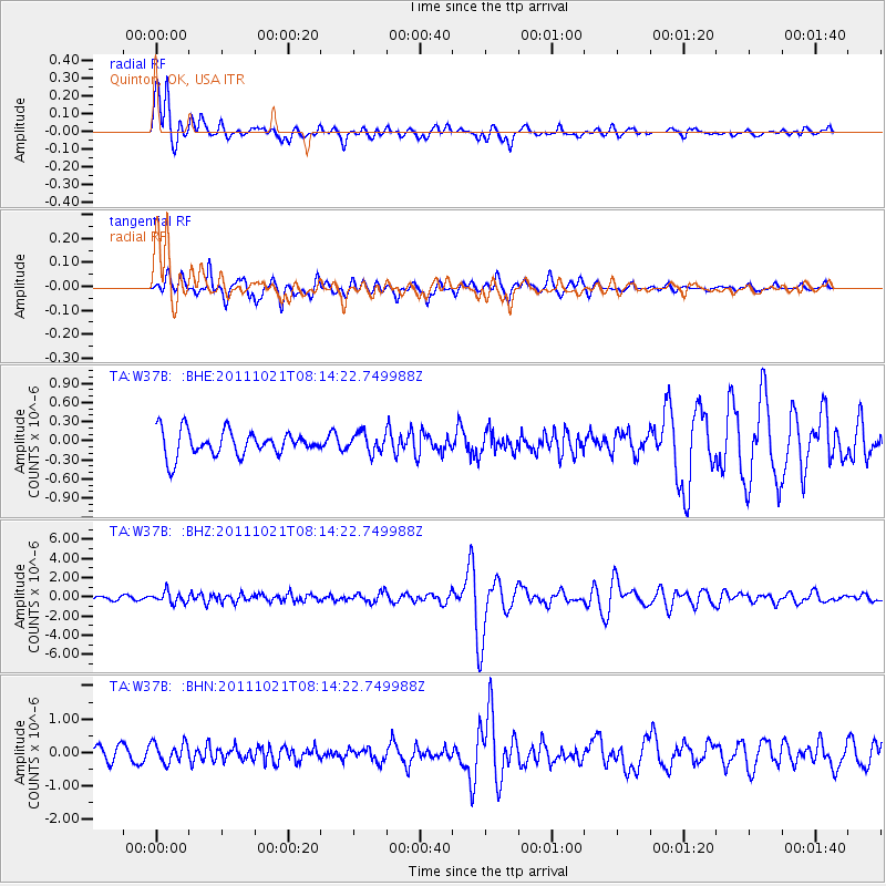
Signal To Noise
| Channel | StoN | STA | LTA |
| TA:W37B: :BHZ:20111021T08:14:22.749988Z | 3.1517231 | 5.768164E-7 | 1.830162E-7 |
| TA:W37B: :BHN:20111021T08:14:22.749988Z | 1.4226843 | 3.008483E-7 | 2.1146526E-7 |
| TA:W37B: :BHE:20111021T08:14:22.749988Z | 0.7622704 | 1.4973166E-7 | 1.9642854E-7 |
| Arrivals |
| Ps | 1.8 SECOND |
| PpPs | 7.5 SECOND |
| PsPs/PpSs | 9.3 SECOND |


