You are here: Home > Network List > TA - USArray Transportable Network (new EarthScope stations) Stations List
> Station 141A Papa Simpson, Farm, Arcadia, LA, USA > Earthquake Result Viewer
141A Papa Simpson, Farm, Arcadia, LA, USA - Earthquake Result Viewer
| Earthquake location: |
Hokkaido, Japan Region |
| Earthquake latitude/longitude: |
43.9/142.5 |
| Earthquake time(UTC): |
2011/10/21 (294) 08:02:37 GMT |
| Earthquake Depth: |
187 km |
| Earthquake Magnitude: |
5.9 MB, 6.1 MW, 6.1 MW |
| Earthquake Catalog/Contributor: |
WHDF/NEIC |
|
| Network: |
TA USArray Transportable Network (new EarthScope stations) |
| Station: |
141A Papa Simpson, Farm, Arcadia, LA, USA |
| Lat/Lon: |
32.60 N/92.90 W |
| Elevation: |
91 m |
|
| Distance: |
88.6 deg |
| Az: |
44.013 deg |
| Baz: |
323.476 deg |
| Ray Param: |
0.042017873 |
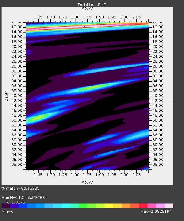
| Estimated Moho Depth: |
11.5 km |
| Estimated Crust Vp/Vs: |
1.84 |
| Assumed Crust Vp: |
6.245 km/s |
| Estimated Crust Vs: |
3.399 km/s |
| Estimated Crust Poisson's Ratio: |
0.29 |
|
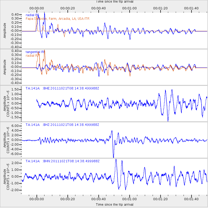
| Radial Match: |
80.15285 % |
| Radial Bump: |
400 |
| Transverse Match: |
75.24405 % |
| Transverse Bump: |
383 |
| SOD ConfigId: |
424168 |
| Insert Time: |
2012-02-10 01:41:45.325 +0000 |
| GWidth: |
2.5 |
| Max Bumps: |
400 |
| Tol: |
0.001 |
|
Signal To Noise
| Channel | StoN | STA | LTA |
| TA:141A: :BHZ:20111021T08:14:38.499988Z | 3.6770623 | 5.7858034E-7 | 1.5734854E-7 |
| TA:141A: :BHN:20111021T08:14:38.499988Z | 0.7202879 | 2.816385E-7 | 3.9100823E-7 |
| TA:141A: :BHE:20111021T08:14:38.499988Z | 1.506472 | 3.5928977E-7 | 2.3849748E-7 |
| Arrivals |
| Ps | 1.6 SECOND |
| PpPs | 5.1 SECOND |
| PsPs/PpSs | 6.7 SECOND |


