You are here: Home > Network List > TA - USArray Transportable Network (new EarthScope stations) Stations List
> Station Z41A Richland Creek Farm, El Dorado, AR, USA > Earthquake Result Viewer
Z41A Richland Creek Farm, El Dorado, AR, USA - Earthquake Result Viewer
| Earthquake location: |
Hokkaido, Japan Region |
| Earthquake latitude/longitude: |
43.9/142.5 |
| Earthquake time(UTC): |
2011/10/21 (294) 08:02:37 GMT |
| Earthquake Depth: |
187 km |
| Earthquake Magnitude: |
5.9 MB, 6.1 MW, 6.1 MW |
| Earthquake Catalog/Contributor: |
WHDF/NEIC |
|
| Network: |
TA USArray Transportable Network (new EarthScope stations) |
| Station: |
Z41A Richland Creek Farm, El Dorado, AR, USA |
| Lat/Lon: |
33.26 N/92.80 W |
| Elevation: |
62 m |
|
| Distance: |
88.2 deg |
| Az: |
43.557 deg |
| Baz: |
323.519 deg |
| Ray Param: |
0.04236092 |
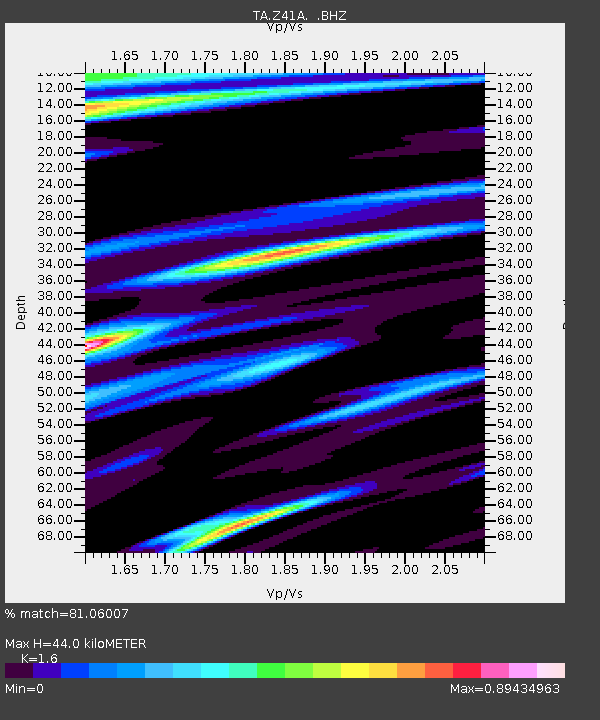
| Estimated Moho Depth: |
44.0 km |
| Estimated Crust Vp/Vs: |
1.60 |
| Assumed Crust Vp: |
6.245 km/s |
| Estimated Crust Vs: |
3.903 km/s |
| Estimated Crust Poisson's Ratio: |
0.18 |
|
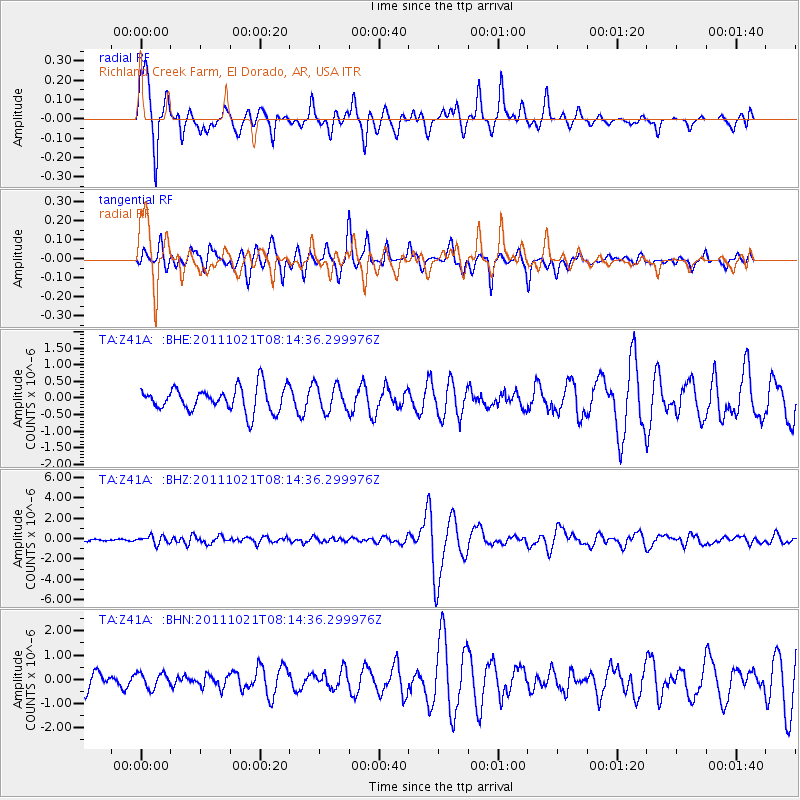
| Radial Match: |
81.06007 % |
| Radial Bump: |
341 |
| Transverse Match: |
68.673485 % |
| Transverse Bump: |
398 |
| SOD ConfigId: |
424168 |
| Insert Time: |
2012-02-10 01:42:23.791 +0000 |
| GWidth: |
2.5 |
| Max Bumps: |
400 |
| Tol: |
0.001 |
|
Signal To Noise
| Channel | StoN | STA | LTA |
| TA:Z41A: :BHZ:20111021T08:14:36.299976Z | 2.710401 | 3.958276E-7 | 1.4604025E-7 |
| TA:Z41A: :BHN:20111021T08:14:36.299976Z | 0.8015176 | 3.1231122E-7 | 3.8964984E-7 |
| TA:Z41A: :BHE:20111021T08:14:36.299976Z | 1.0790557 | 3.9374103E-7 | 3.6489408E-7 |
| Arrivals |
| Ps | 4.3 SECOND |
| PpPs | 18 SECOND |
| PsPs/PpSs | 22 SECOND |


