You are here: Home > Network List > G - GEOSCOPE Stations List
> Station FOMA Nahampoana reservation, Fort Dauphin, Madagascar > Earthquake Result Viewer
FOMA Nahampoana reservation, Fort Dauphin, Madagascar - Earthquake Result Viewer
| Earthquake location: |
Southern Sumatra, Indonesia |
| Earthquake latitude/longitude: |
-0.7/99.9 |
| Earthquake time(UTC): |
2009/09/30 (273) 10:16:09 GMT |
| Earthquake Depth: |
81 km |
| Earthquake Magnitude: |
7.1 MB, 7.5 MW, 7.5 MW |
| Earthquake Catalog/Contributor: |
WHDF/NEIC |
|
| Network: |
G GEOSCOPE |
| Station: |
FOMA Nahampoana reservation, Fort Dauphin, Madagascar |
| Lat/Lon: |
24.98 S/46.98 E |
| Elevation: |
26 m |
|
| Distance: |
56.4 deg |
| Az: |
240.287 deg |
| Baz: |
73.117 deg |
| Ray Param: |
0.06390991 |
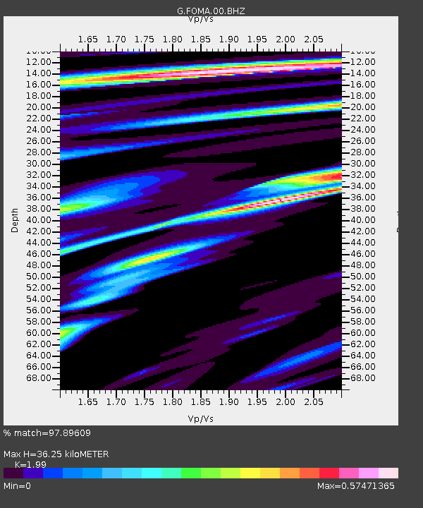
| Estimated Moho Depth: |
36.25 km |
| Estimated Crust Vp/Vs: |
1.99 |
| Assumed Crust Vp: |
6.183 km/s |
| Estimated Crust Vs: |
3.107 km/s |
| Estimated Crust Poisson's Ratio: |
0.33 |
|
| Radial Match: |
97.89609 % |
| Radial Bump: |
311 |
| Transverse Match: |
84.743744 % |
| Transverse Bump: |
400 |
| SOD ConfigId: |
2622 |
| Insert Time: |
2010-02-26 22:35:16.095 +0000 |
| GWidth: |
2.5 |
| Max Bumps: |
400 |
| Tol: |
0.001 |
|

Signal To Noise
| Channel | StoN | STA | LTA |
| G:FOMA:00:BHZ:20090930T10:25:11.950012Z | 9.919302 | 1.1200387E-5 | 1.1291507E-6 |
| G:FOMA:00:BHN:20090930T10:25:11.950012Z | 2.3659878 | 1.478641E-6 | 6.249572E-7 |
| G:FOMA:00:BHE:20090930T10:25:11.950012Z | 6.077787 | 5.5624896E-6 | 9.152163E-7 |
| Arrivals |
| Ps | 6.0 SECOND |
| PpPs | 17 SECOND |
| PsPs/PpSs | 23 SECOND |


