You are here: Home > Network List > TA - USArray Transportable Network (new EarthScope stations) Stations List
> Station Y45A Yeager Farm, Coffeeville, MS, USA > Earthquake Result Viewer
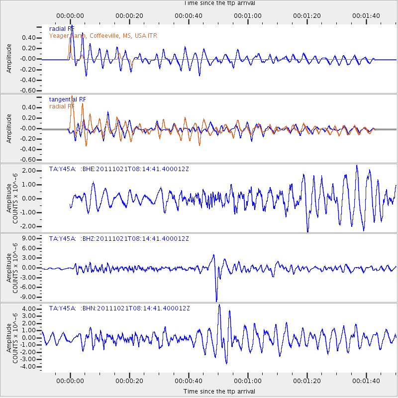
Y45A Yeager Farm, Coffeeville, MS, USA - Earthquake Result Viewer
*The percent match for this event was below the threshold and hence no stack was calculated.
| Earthquake location: |
Hokkaido, Japan Region |
| Earthquake latitude/longitude: |
43.9/142.5 |
| Earthquake time(UTC): |
2011/10/21 (294) 08:02:37 GMT |
| Earthquake Depth: |
187 km |
| Earthquake Magnitude: |
5.9 MB, 6.1 MW, 6.1 MW |
| Earthquake Catalog/Contributor: |
WHDF/NEIC |
|
| Network: |
TA USArray Transportable Network (new EarthScope stations) |
| Station: |
Y45A Yeager Farm, Coffeeville, MS, USA |
| Lat/Lon: |
33.87 N/89.54 W |
| Elevation: |
106 m |
|
| Distance: |
89.3 deg |
| Az: |
40.991 deg |
| Baz: |
325.255 deg |
| Ray Param: |
$rayparam |
*The percent match for this event was below the threshold and hence was not used in the summary stack. |
|
| Radial Match: |
72.428955 % |
| Radial Bump: |
364 |
| Transverse Match: |
72.96424 % |
| Transverse Bump: |
372 |
| SOD ConfigId: |
424168 |
| Insert Time: |
2012-02-10 01:43:40.398 +0000 |
| GWidth: |
2.5 |
| Max Bumps: |
400 |
| Tol: |
0.001 |
|
Signal To Noise
| Channel | StoN | STA | LTA |
| TA:Y45A: :BHZ:20111021T08:14:41.400012Z | 2.5675383 | 7.4089166E-7 | 2.885611E-7 |
| TA:Y45A: :BHN:20111021T08:14:41.400012Z | 0.95315236 | 6.587872E-7 | 6.9116675E-7 |
| TA:Y45A: :BHE:20111021T08:14:41.400012Z | 1.1708218 | 5.246154E-7 | 4.480745E-7 |
| Arrivals |
| Ps | |
| PpPs | |
| PsPs/PpSs | |


