You are here: Home > Network List > TA - USArray Transportable Network (new EarthScope stations) Stations List
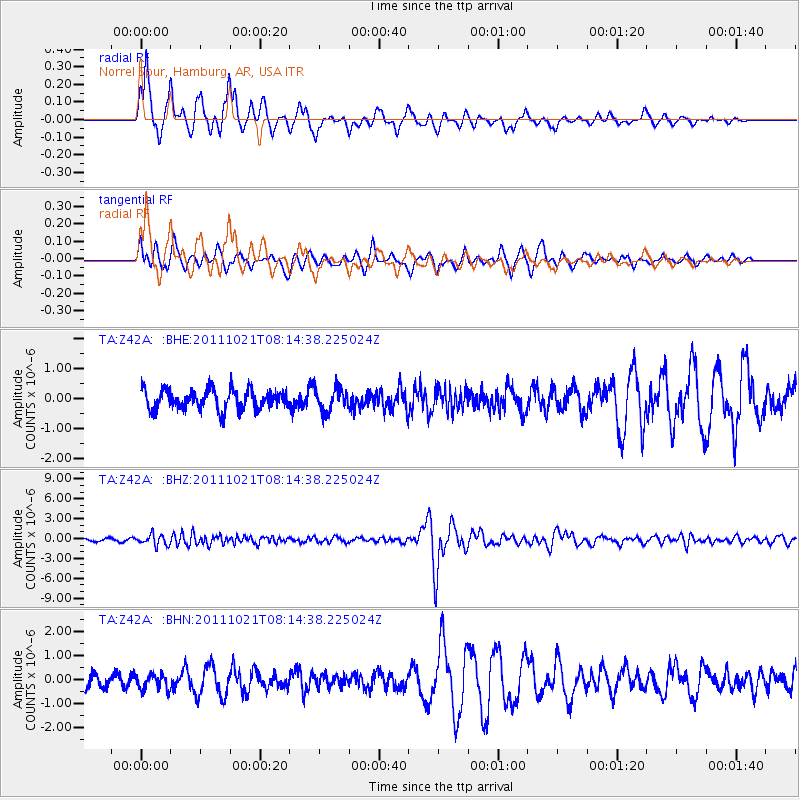
> Station Z42A Norrel Spur, Hamburg, AR, USA > Earthquake Result Viewer
Z42A Norrel Spur, Hamburg, AR, USA - Earthquake Result Viewer
| Earthquake location: |
Hokkaido, Japan Region |
| Earthquake latitude/longitude: |
43.9/142.5 |
| Earthquake time(UTC): |
2011/10/21 (294) 08:02:37 GMT |
| Earthquake Depth: |
187 km |
| Earthquake Magnitude: |
5.9 MB, 6.1 MW, 6.1 MW |
| Earthquake Catalog/Contributor: |
WHDF/NEIC |
|
| Network: |
TA USArray Transportable Network (new EarthScope stations) |
| Station: |
Z42A Norrel Spur, Hamburg, AR, USA |
| Lat/Lon: |
33.27 N/91.95 W |
| Elevation: |
39 m |
|
| Distance: |
88.6 deg |
| Az: |
42.969 deg |
| Baz: |
323.969 deg |
| Ray Param: |
0.042062316 |
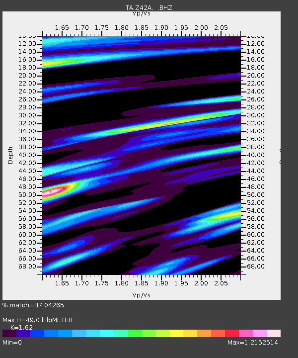
| Estimated Moho Depth: |
49.0 km |
| Estimated Crust Vp/Vs: |
1.62 |
| Assumed Crust Vp: |
6.201 km/s |
| Estimated Crust Vs: |
3.828 km/s |
| Estimated Crust Poisson's Ratio: |
0.19 |
|
| Radial Match: |
87.04265 % |
| Radial Bump: |
314 |
| Transverse Match: |
64.5976 % |
| Transverse Bump: |
391 |
| SOD ConfigId: |
424168 |
| Insert Time: |
2012-02-10 01:44:07.977 +0000 |
| GWidth: |
2.5 |
| Max Bumps: |
400 |
| Tol: |
0.001 |
|
Signal To Noise
| Channel | StoN | STA | LTA |
| TA:Z42A: :BHZ:20111021T08:14:38.225024Z | 4.6087546 | 7.9467327E-7 | 1.724269E-7 |
| TA:Z42A: :BHN:20111021T08:14:38.225024Z | 1.0984967 | 3.1659414E-7 | 2.8820673E-7 |
| TA:Z42A: :BHE:20111021T08:14:38.225024Z | 1.1902695 | 3.9228644E-7 | 3.2957783E-7 |
| Arrivals |
| Ps | 5.0 SECOND |
| PpPs | 20 SECOND |
| PsPs/PpSs | 25 SECOND |


