You are here: Home > Network List > TA - USArray Transportable Network (new EarthScope stations) Stations List
> Station Y41A Eaglette Bearden, AR, USA > Earthquake Result Viewer
Y41A Eaglette Bearden, AR, USA - Earthquake Result Viewer

| Earthquake location: |
Hokkaido, Japan Region |
| Earthquake latitude/longitude: |
43.9/142.5 |
| Earthquake time(UTC): |
2011/10/21 (294) 08:02:37 GMT |
| Earthquake Depth: |
187 km |
| Earthquake Magnitude: |
5.9 MB, 6.1 MW, 6.1 MW |
| Earthquake Catalog/Contributor: |
WHDF/NEIC |
|
| Network: |
TA USArray Transportable Network (new EarthScope stations) |
| Station: |
Y41A Eaglette Bearden, AR, USA |
| Lat/Lon: |
33.88 N/92.61 W |
| Elevation: |
99 m |
|
| Distance: |
87.8 deg |
| Az: |
43.059 deg |
| Baz: |
323.606 deg |
| Ray Param: |
0.04265916 |
| Estimated Moho Depth: |
13.0 km |
| Estimated Crust Vp/Vs: |
1.60 |
| Assumed Crust Vp: |
6.245 km/s |
| Estimated Crust Vs: |
3.903 km/s |
| Estimated Crust Poisson's Ratio: |
0.18 |
|
| Radial Match: |
87.39891 % |
| Radial Bump: |
387 |
| Transverse Match: |
68.49652 % |
| Transverse Bump: |
400 |
| SOD ConfigId: |
424168 |
| Insert Time: |
2012-02-10 01:44:40.073 +0000 |
| GWidth: |
2.5 |
| Max Bumps: |
400 |
| Tol: |
0.001 |
|
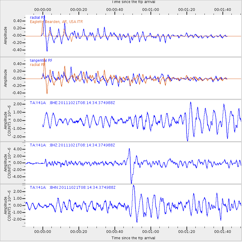
Signal To Noise
| Channel | StoN | STA | LTA |
| TA:Y41A: :BHZ:20111021T08:14:34.374988Z | 3.416488 | 4.3714584E-7 | 1.2795182E-7 |
| TA:Y41A: :BHN:20111021T08:14:34.374988Z | 0.4366538 | 1.6091013E-7 | 3.6850736E-7 |
| TA:Y41A: :BHE:20111021T08:14:34.374988Z | 1.0444938 | 4.4079093E-7 | 4.2201393E-7 |
| Arrivals |
| Ps | 1.3 SECOND |
| PpPs | 5.3 SECOND |
| PsPs/PpSs | 6.6 SECOND |


