You are here: Home > Network List > TA - USArray Transportable Network (new EarthScope stations) Stations List
> Station X44A Crenshaw, MS, USA > Earthquake Result Viewer
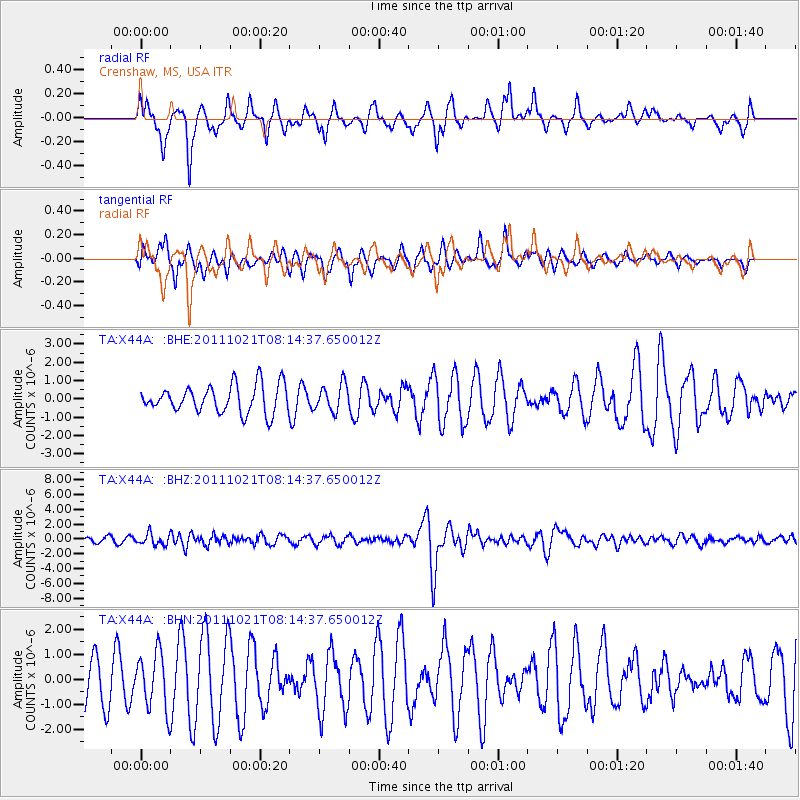
X44A Crenshaw, MS, USA - Earthquake Result Viewer
*The percent match for this event was below the threshold and hence no stack was calculated.
| Earthquake location: |
Hokkaido, Japan Region |
| Earthquake latitude/longitude: |
43.9/142.5 |
| Earthquake time(UTC): |
2011/10/21 (294) 08:02:37 GMT |
| Earthquake Depth: |
187 km |
| Earthquake Magnitude: |
5.9 MB, 6.1 MW, 6.1 MW |
| Earthquake Catalog/Contributor: |
WHDF/NEIC |
|
| Network: |
TA USArray Transportable Network (new EarthScope stations) |
| Station: |
X44A Crenshaw, MS, USA |
| Lat/Lon: |
34.50 N/90.15 W |
| Elevation: |
109 m |
|
| Distance: |
88.4 deg |
| Az: |
41.039 deg |
| Baz: |
324.918 deg |
| Ray Param: |
$rayparam |
*The percent match for this event was below the threshold and hence was not used in the summary stack. |
|
| Radial Match: |
58.112656 % |
| Radial Bump: |
337 |
| Transverse Match: |
40.94404 % |
| Transverse Bump: |
358 |
| SOD ConfigId: |
424168 |
| Insert Time: |
2012-02-10 01:44:54.078 +0000 |
| GWidth: |
2.5 |
| Max Bumps: |
400 |
| Tol: |
0.001 |
|
Signal To Noise
| Channel | StoN | STA | LTA |
| TA:X44A: :BHZ:20111021T08:14:37.650012Z | 2.7697477 | 7.573513E-7 | 2.734369E-7 |
| TA:X44A: :BHN:20111021T08:14:37.650012Z | 1.3296659 | 1.1281628E-6 | 8.4845584E-7 |
| TA:X44A: :BHE:20111021T08:14:37.650012Z | 0.966281 | 7.3199413E-7 | 7.575376E-7 |
| Arrivals |
| Ps | |
| PpPs | |
| PsPs/PpSs | |


