You are here: Home > Network List > TA - USArray Transportable Network (new EarthScope stations) Stations List
> Station Q42A Golden Eagle, IL, USA > Earthquake Result Viewer
Q42A Golden Eagle, IL, USA - Earthquake Result Viewer
| Earthquake location: |
Hokkaido, Japan Region |
| Earthquake latitude/longitude: |
43.9/142.5 |
| Earthquake time(UTC): |
2011/10/21 (294) 08:02:37 GMT |
| Earthquake Depth: |
187 km |
| Earthquake Magnitude: |
5.9 MB, 6.1 MW, 6.1 MW |
| Earthquake Catalog/Contributor: |
WHDF/NEIC |
|
| Network: |
TA USArray Transportable Network (new EarthScope stations) |
| Station: |
Q42A Golden Eagle, IL, USA |
| Lat/Lon: |
38.91 N/90.53 W |
| Elevation: |
175 m |
|
| Distance: |
84.7 deg |
| Az: |
38.746 deg |
| Baz: |
324.55 deg |
| Ray Param: |
0.044869274 |
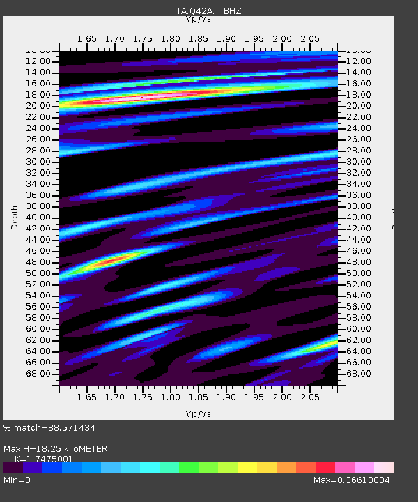
| Estimated Moho Depth: |
18.25 km |
| Estimated Crust Vp/Vs: |
1.75 |
| Assumed Crust Vp: |
6.498 km/s |
| Estimated Crust Vs: |
3.718 km/s |
| Estimated Crust Poisson's Ratio: |
0.26 |
|
| Radial Match: |
88.571434 % |
| Radial Bump: |
400 |
| Transverse Match: |
68.08924 % |
| Transverse Bump: |
400 |
| SOD ConfigId: |
424168 |
| Insert Time: |
2012-02-10 01:45:11.078 +0000 |
| GWidth: |
2.5 |
| Max Bumps: |
400 |
| Tol: |
0.001 |
|
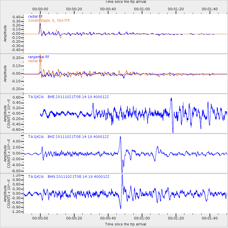
Signal To Noise
| Channel | StoN | STA | LTA |
| TA:Q42A: :BHZ:20111021T08:14:19.400012Z | 5.701416 | 9.0224E-7 | 1.5824841E-7 |
| TA:Q42A: :BHN:20111021T08:14:19.400012Z | 1.9758805 | 1.8622775E-7 | 9.425051E-8 |
| TA:Q42A: :BHE:20111021T08:14:19.400012Z | 2.2243946 | 1.3675995E-7 | 6.1481884E-8 |
| Arrivals |
| Ps | 2.2 SECOND |
| PpPs | 7.5 SECOND |
| PsPs/PpSs | 9.7 SECOND |


