You are here: Home > Network List > TA - USArray Transportable Network (new EarthScope stations) Stations List
> Station K39A Oelwein, IA, USA > Earthquake Result Viewer
K39A Oelwein, IA, USA - Earthquake Result Viewer
| Earthquake location: |
Hokkaido, Japan Region |
| Earthquake latitude/longitude: |
43.9/142.5 |
| Earthquake time(UTC): |
2011/10/21 (294) 08:02:37 GMT |
| Earthquake Depth: |
187 km |
| Earthquake Magnitude: |
5.9 MB, 6.1 MW, 6.1 MW |
| Earthquake Catalog/Contributor: |
WHDF/NEIC |
|
| Network: |
TA USArray Transportable Network (new EarthScope stations) |
| Station: |
K39A Oelwein, IA, USA |
| Lat/Lon: |
42.71 N/91.89 W |
| Elevation: |
332 m |
|
| Distance: |
81.0 deg |
| Az: |
37.342 deg |
| Baz: |
323.493 deg |
| Ray Param: |
0.04742889 |
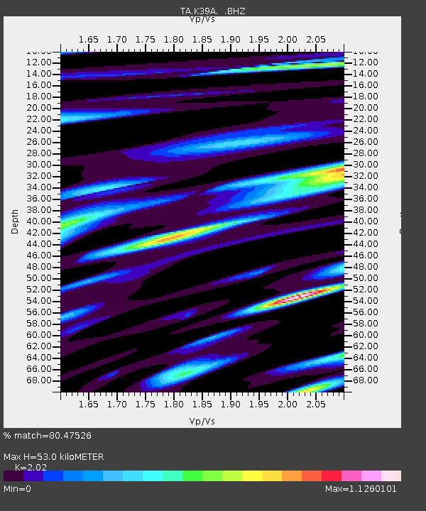
| Estimated Moho Depth: |
53.0 km |
| Estimated Crust Vp/Vs: |
2.02 |
| Assumed Crust Vp: |
6.53 km/s |
| Estimated Crust Vs: |
3.233 km/s |
| Estimated Crust Poisson's Ratio: |
0.34 |
|
| Radial Match: |
80.47526 % |
| Radial Bump: |
400 |
| Transverse Match: |
48.847057 % |
| Transverse Bump: |
400 |
| SOD ConfigId: |
424168 |
| Insert Time: |
2012-02-10 01:47:09.224 +0000 |
| GWidth: |
2.5 |
| Max Bumps: |
400 |
| Tol: |
0.001 |
|

Signal To Noise
| Channel | StoN | STA | LTA |
| TA:K39A: :BHZ:20111021T08:14:00.624988Z | 3.7206123 | 7.041906E-7 | 1.8926738E-7 |
| TA:K39A: :BHN:20111021T08:14:00.624988Z | 2.2125428 | 4.0265687E-7 | 1.819883E-7 |
| TA:K39A: :BHE:20111021T08:14:00.624988Z | 2.018722 | 2.4974432E-7 | 1.2371407E-7 |
| Arrivals |
| Ps | 8.5 SECOND |
| PpPs | 24 SECOND |
| PsPs/PpSs | 32 SECOND |


