You are here: Home > Network List > TA - USArray Transportable Network (new EarthScope stations) Stations List
> Station M39A Webster, IA, USA > Earthquake Result Viewer
M39A Webster, IA, USA - Earthquake Result Viewer
| Earthquake location: |
Hokkaido, Japan Region |
| Earthquake latitude/longitude: |
43.9/142.5 |
| Earthquake time(UTC): |
2011/10/21 (294) 08:02:37 GMT |
| Earthquake Depth: |
187 km |
| Earthquake Magnitude: |
5.9 MB, 6.1 MW, 6.1 MW |
| Earthquake Catalog/Contributor: |
WHDF/NEIC |
|
| Network: |
TA USArray Transportable Network (new EarthScope stations) |
| Station: |
M39A Webster, IA, USA |
| Lat/Lon: |
41.48 N/92.17 W |
| Elevation: |
264 m |
|
| Distance: |
81.9 deg |
| Az: |
38.252 deg |
| Baz: |
323.438 deg |
| Ray Param: |
0.046836395 |
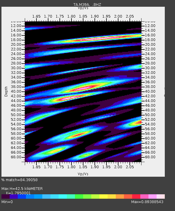
| Estimated Moho Depth: |
42.5 km |
| Estimated Crust Vp/Vs: |
1.80 |
| Assumed Crust Vp: |
6.498 km/s |
| Estimated Crust Vs: |
3.62 km/s |
| Estimated Crust Poisson's Ratio: |
0.27 |
|
| Radial Match: |
84.39058 % |
| Radial Bump: |
400 |
| Transverse Match: |
53.855904 % |
| Transverse Bump: |
400 |
| SOD ConfigId: |
424168 |
| Insert Time: |
2012-02-10 01:47:48.429 +0000 |
| GWidth: |
2.5 |
| Max Bumps: |
400 |
| Tol: |
0.001 |
|

Signal To Noise
| Channel | StoN | STA | LTA |
| TA:M39A: :BHZ:20111021T08:14:05.100024Z | 5.407767 | 1.0802728E-6 | 1.9976319E-7 |
| TA:M39A: :BHN:20111021T08:14:05.100024Z | 2.3609498 | 4.1677626E-7 | 1.7652907E-7 |
| TA:M39A: :BHE:20111021T08:14:05.100024Z | 2.0387094 | 3.8957134E-7 | 1.9108724E-7 |
| Arrivals |
| Ps | 5.3 SECOND |
| PpPs | 18 SECOND |
| PsPs/PpSs | 23 SECOND |


