You are here: Home > Network List > TA - USArray Transportable Network (new EarthScope stations) Stations List
> Station V43A Jonesboro, AR, USA > Earthquake Result Viewer
V43A Jonesboro, AR, USA - Earthquake Result Viewer
| Earthquake location: |
Hokkaido, Japan Region |
| Earthquake latitude/longitude: |
43.9/142.5 |
| Earthquake time(UTC): |
2011/10/21 (294) 08:02:37 GMT |
| Earthquake Depth: |
187 km |
| Earthquake Magnitude: |
5.9 MB, 6.1 MW, 6.1 MW |
| Earthquake Catalog/Contributor: |
WHDF/NEIC |
|
| Network: |
TA USArray Transportable Network (new EarthScope stations) |
| Station: |
V43A Jonesboro, AR, USA |
| Lat/Lon: |
35.79 N/90.54 W |
| Elevation: |
74 m |
|
| Distance: |
87.2 deg |
| Az: |
40.565 deg |
| Baz: |
324.672 deg |
| Ray Param: |
0.043058958 |
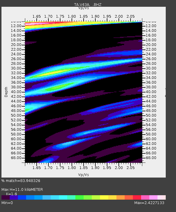
| Estimated Moho Depth: |
11.0 km |
| Estimated Crust Vp/Vs: |
1.60 |
| Assumed Crust Vp: |
6.273 km/s |
| Estimated Crust Vs: |
3.921 km/s |
| Estimated Crust Poisson's Ratio: |
0.18 |
|
| Radial Match: |
83.948326 % |
| Radial Bump: |
367 |
| Transverse Match: |
61.248264 % |
| Transverse Bump: |
360 |
| SOD ConfigId: |
424168 |
| Insert Time: |
2012-02-10 01:49:27.854 +0000 |
| GWidth: |
2.5 |
| Max Bumps: |
400 |
| Tol: |
0.001 |
|
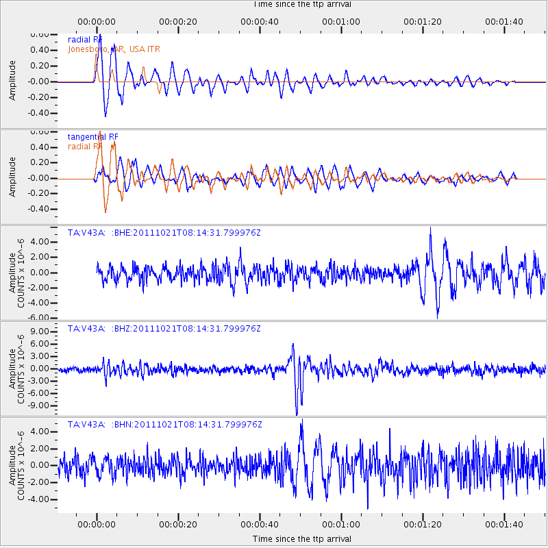
Signal To Noise
| Channel | StoN | STA | LTA |
| TA:V43A: :BHZ:20111021T08:14:31.799976Z | 3.2349334 | 1.2851762E-6 | 3.9728056E-7 |
| TA:V43A: :BHN:20111021T08:14:31.799976Z | 1.2016346 | 1.0337509E-6 | 8.6028723E-7 |
| TA:V43A: :BHE:20111021T08:14:31.799976Z | 1.5415386 | 1.2511782E-6 | 8.116425E-7 |
| Arrivals |
| Ps | 1.1 SECOND |
| PpPs | 4.5 SECOND |
| PsPs/PpSs | 5.5 SECOND |


