You are here: Home > Network List > TA - USArray Transportable Network (new EarthScope stations) Stations List
> Station H40A Chili, WI, USA > Earthquake Result Viewer
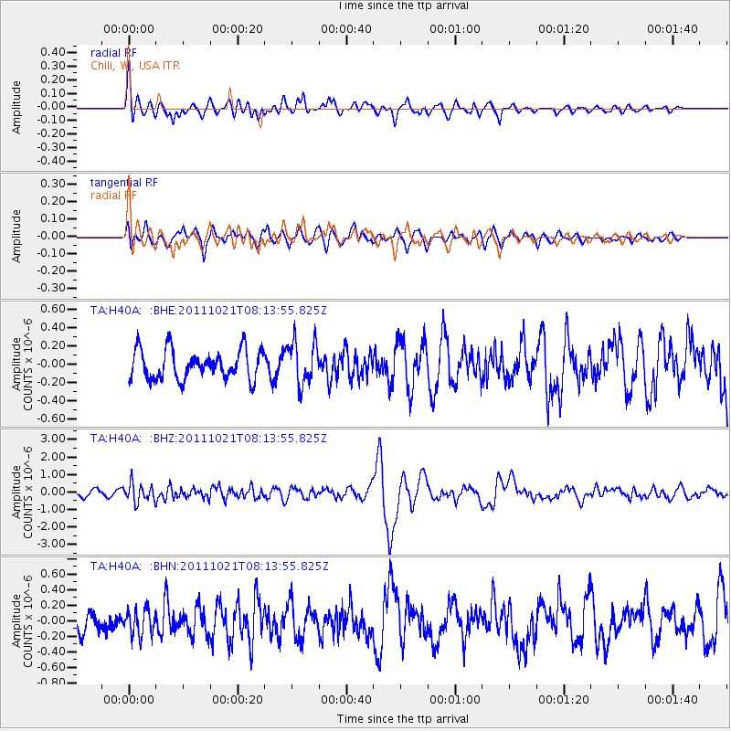
H40A Chili, WI, USA - Earthquake Result Viewer
*The percent match for this event was below the threshold and hence no stack was calculated.
| Earthquake location: |
Hokkaido, Japan Region |
| Earthquake latitude/longitude: |
43.9/142.5 |
| Earthquake time(UTC): |
2011/10/21 (294) 08:02:37 GMT |
| Earthquake Depth: |
187 km |
| Earthquake Magnitude: |
5.9 MB, 6.1 MW, 6.1 MW |
| Earthquake Catalog/Contributor: |
WHDF/NEIC |
|
| Network: |
TA USArray Transportable Network (new EarthScope stations) |
| Station: |
H40A Chili, WI, USA |
| Lat/Lon: |
44.62 N/90.39 W |
| Elevation: |
372 m |
|
| Distance: |
80.1 deg |
| Az: |
35.306 deg |
| Baz: |
324.189 deg |
| Ray Param: |
$rayparam |
*The percent match for this event was below the threshold and hence was not used in the summary stack. |
|
| Radial Match: |
74.18221 % |
| Radial Bump: |
400 |
| Transverse Match: |
60.54235 % |
| Transverse Bump: |
400 |
| SOD ConfigId: |
424168 |
| Insert Time: |
2012-02-10 01:50:24.553 +0000 |
| GWidth: |
2.5 |
| Max Bumps: |
400 |
| Tol: |
0.001 |
|
Signal To Noise
| Channel | StoN | STA | LTA |
| TA:H40A: :BHZ:20111021T08:13:55.825Z | 1.8002626 | 5.1527655E-7 | 2.8622298E-7 |
| TA:H40A: :BHN:20111021T08:13:55.825Z | 1.3062207 | 1.653912E-7 | 1.2661812E-7 |
| TA:H40A: :BHE:20111021T08:13:55.825Z | 1.4762237 | 2.3448607E-7 | 1.5884183E-7 |
| Arrivals |
| Ps | |
| PpPs | |
| PsPs/PpSs | |


