You are here: Home > Network List > II - Global Seismograph Network (GSN - IRIS/IDA) Stations List
> Station TAU Hobart, Tasmania, Australia > Earthquake Result Viewer
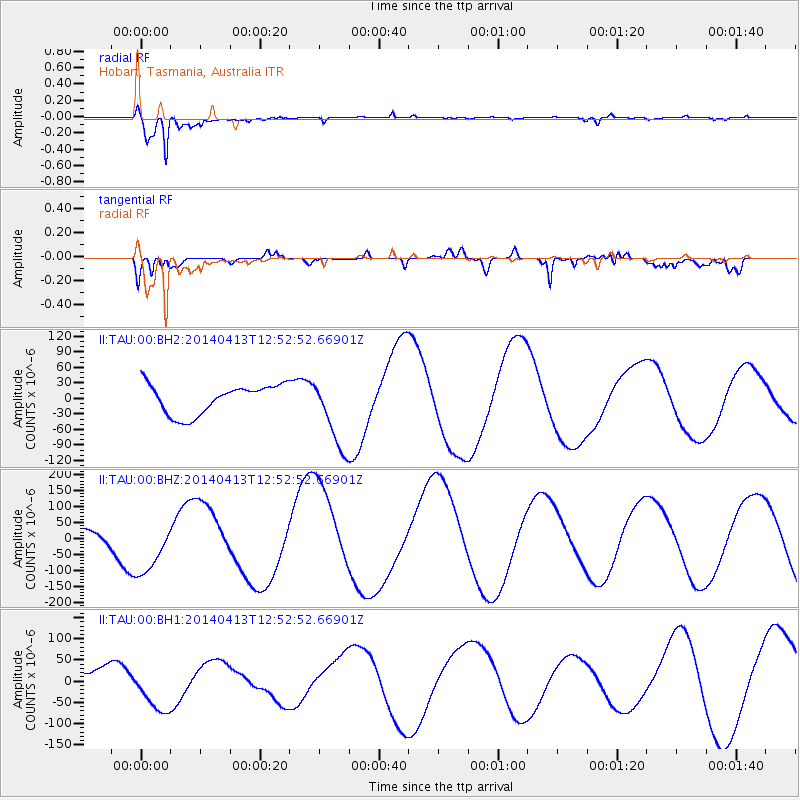
TAU Hobart, Tasmania, Australia - Earthquake Result Viewer
*The percent match for this event was below the threshold and hence no stack was calculated.
| Earthquake location: |
Solomon Islands |
| Earthquake latitude/longitude: |
-11.5/162.3 |
| Earthquake time(UTC): |
2014/04/13 (103) 12:46:43 GMT |
| Earthquake Depth: |
31 km |
| Earthquake Magnitude: |
5.7 MB |
| Earthquake Catalog/Contributor: |
NEIC PDE/NEIC COMCAT |
|
| Network: |
II Global Seismograph Network (GSN - IRIS/IDA) |
| Station: |
TAU Hobart, Tasmania, Australia |
| Lat/Lon: |
42.91 S/147.32 E |
| Elevation: |
132 m |
|
| Distance: |
33.9 deg |
| Az: |
199.921 deg |
| Baz: |
27.042 deg |
| Ray Param: |
$rayparam |
*The percent match for this event was below the threshold and hence was not used in the summary stack. |
|
| Radial Match: |
95.03758 % |
| Radial Bump: |
350 |
| Transverse Match: |
61.85207 % |
| Transverse Bump: |
400 |
| SOD ConfigId: |
3390531 |
| Insert Time: |
2019-04-11 09:12:02.546 +0000 |
| GWidth: |
2.5 |
| Max Bumps: |
400 |
| Tol: |
0.001 |
|
Signal To Noise
| Channel | StoN | STA | LTA |
| II:TAU:00:BHZ:20140413T12:52:52.66901Z | 5.1598353 | 9.4497555E-5 | 1.8314064E-5 |
| II:TAU:00:BH1:20140413T12:52:52.66901Z | 2.5384989 | 5.673986E-5 | 2.2351738E-5 |
| II:TAU:00:BH2:20140413T12:52:52.66901Z | 2.737372 | 7.739225E-5 | 2.8272465E-5 |
| Arrivals |
| Ps | |
| PpPs | |
| PsPs/PpSs | |


