You are here: Home > Network List > TA - USArray Transportable Network (new EarthScope stations) Stations List
> Station E41A Kenton, MI, USA > Earthquake Result Viewer
E41A Kenton, MI, USA - Earthquake Result Viewer
| Earthquake location: |
Hokkaido, Japan Region |
| Earthquake latitude/longitude: |
43.9/142.5 |
| Earthquake time(UTC): |
2011/10/21 (294) 08:02:37 GMT |
| Earthquake Depth: |
187 km |
| Earthquake Magnitude: |
5.9 MB, 6.1 MW, 6.1 MW |
| Earthquake Catalog/Contributor: |
WHDF/NEIC |
|
| Network: |
TA USArray Transportable Network (new EarthScope stations) |
| Station: |
E41A Kenton, MI, USA |
| Lat/Lon: |
46.46 N/88.96 W |
| Elevation: |
377 m |
|
| Distance: |
79.2 deg |
| Az: |
33.389 deg |
| Baz: |
324.859 deg |
| Ray Param: |
0.048672788 |
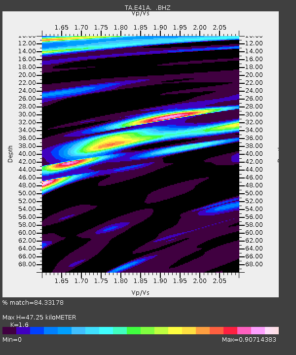
| Estimated Moho Depth: |
47.25 km |
| Estimated Crust Vp/Vs: |
1.60 |
| Assumed Crust Vp: |
6.467 km/s |
| Estimated Crust Vs: |
4.042 km/s |
| Estimated Crust Poisson's Ratio: |
0.18 |
|
| Radial Match: |
84.33178 % |
| Radial Bump: |
400 |
| Transverse Match: |
70.25726 % |
| Transverse Bump: |
400 |
| SOD ConfigId: |
424168 |
| Insert Time: |
2012-02-10 01:53:21.410 +0000 |
| GWidth: |
2.5 |
| Max Bumps: |
400 |
| Tol: |
0.001 |
|
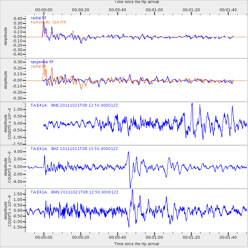
Signal To Noise
| Channel | StoN | STA | LTA |
| TA:E41A: :BHZ:20111021T08:13:50.900012Z | 4.3789296 | 1.0668844E-6 | 2.4364044E-7 |
| TA:E41A: :BHN:20111021T08:13:50.900012Z | 1.6836916 | 3.0081299E-7 | 1.7866276E-7 |
| TA:E41A: :BHE:20111021T08:13:50.900012Z | 1.4160193 | 1.9618385E-7 | 1.3854603E-7 |
| Arrivals |
| Ps | 4.5 SECOND |
| PpPs | 18 SECOND |
| PsPs/PpSs | 23 SECOND |


