You are here: Home > Network List > UW - Pacific Northwest Regional Seismic Network Stations List
> Station LEBA Lebam, WA, USA > Earthquake Result Viewer
LEBA Lebam, WA, USA - Earthquake Result Viewer
| Earthquake location: |
Hokkaido, Japan Region |
| Earthquake latitude/longitude: |
43.9/142.5 |
| Earthquake time(UTC): |
2011/10/21 (294) 08:02:37 GMT |
| Earthquake Depth: |
187 km |
| Earthquake Magnitude: |
5.9 MB, 6.1 MW, 6.1 MW |
| Earthquake Catalog/Contributor: |
WHDF/NEIC |
|
| Network: |
UW Pacific Northwest Regional Seismic Network |
| Station: |
LEBA Lebam, WA, USA |
| Lat/Lon: |
46.55 N/123.56 W |
| Elevation: |
73 m |
|
| Distance: |
62.3 deg |
| Az: |
51.076 deg |
| Baz: |
305.421 deg |
| Ray Param: |
0.05977281 |
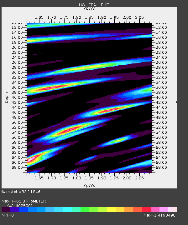
| Estimated Moho Depth: |
65.0 km |
| Estimated Crust Vp/Vs: |
1.60 |
| Assumed Crust Vp: |
6.566 km/s |
| Estimated Crust Vs: |
4.097 km/s |
| Estimated Crust Poisson's Ratio: |
0.18 |
|
| Radial Match: |
93.11846 % |
| Radial Bump: |
400 |
| Transverse Match: |
87.42873 % |
| Transverse Bump: |
400 |
| SOD ConfigId: |
424168 |
| Insert Time: |
2012-02-10 01:58:29.688 +0000 |
| GWidth: |
2.5 |
| Max Bumps: |
400 |
| Tol: |
0.001 |
|
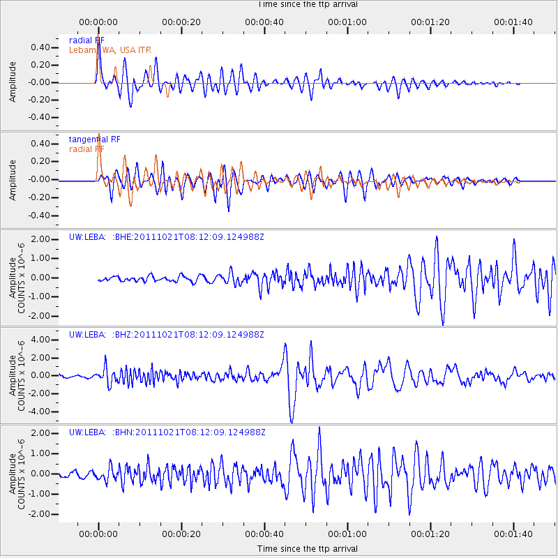
Signal To Noise
| Channel | StoN | STA | LTA |
| UW:LEBA: :BHZ:20111021T08:12:09.124988Z | 6.2733064 | 8.4729373E-7 | 1.3506335E-7 |
| UW:LEBA: :BHN:20111021T08:12:09.124988Z | 2.5919032 | 3.019518E-7 | 1.1649809E-7 |
| UW:LEBA: :BHE:20111021T08:12:09.124988Z | 2.1458502 | 2.8340986E-7 | 1.3207347E-7 |
| Arrivals |
| Ps | 6.3 SECOND |
| PpPs | 24 SECOND |
| PsPs/PpSs | 31 SECOND |


