You are here: Home > Network List > AU - Australian Seismological Centre Stations List
> Station MORW Morawa, Western Australia > Earthquake Result Viewer
MORW Morawa, Western Australia - Earthquake Result Viewer
| Earthquake location: |
Kermadec Islands Region |
| Earthquake latitude/longitude: |
-29.0/-176.2 |
| Earthquake time(UTC): |
2011/10/21 (294) 17:57:16 GMT |
| Earthquake Depth: |
33 km |
| Earthquake Magnitude: |
6.4 MB, 7.5 MS, 7.4 MW, 7.4 MW |
| Earthquake Catalog/Contributor: |
WHDF/NEIC |
|
| Network: |
AU Australian Seismological Centre |
| Station: |
MORW Morawa, Western Australia |
| Lat/Lon: |
29.07 S/116.04 E |
| Elevation: |
296 m |
|
| Distance: |
58.4 deg |
| Az: |
251.987 deg |
| Baz: |
107.886 deg |
| Ray Param: |
0.06280468 |
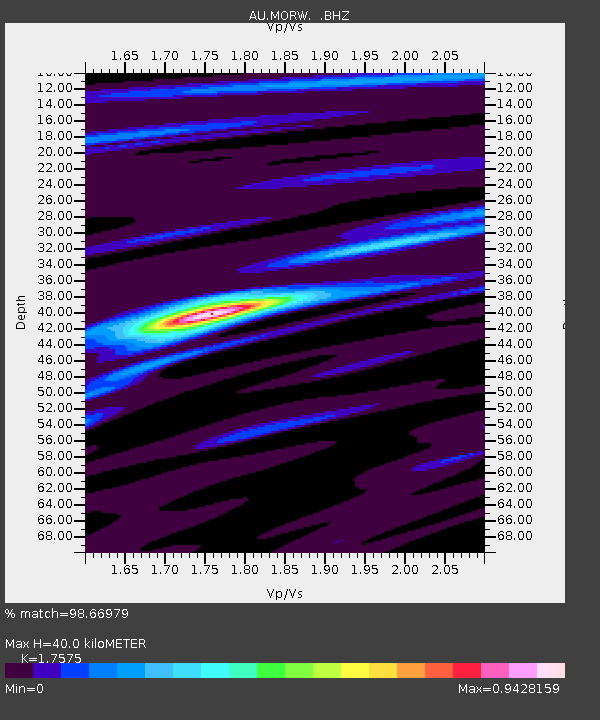
| Estimated Moho Depth: |
40.0 km |
| Estimated Crust Vp/Vs: |
1.76 |
| Assumed Crust Vp: |
6.459 km/s |
| Estimated Crust Vs: |
3.675 km/s |
| Estimated Crust Poisson's Ratio: |
0.26 |
|
| Radial Match: |
98.66979 % |
| Radial Bump: |
216 |
| Transverse Match: |
91.04051 % |
| Transverse Bump: |
323 |
| SOD ConfigId: |
424168 |
| Insert Time: |
2012-02-10 02:10:33.143 +0000 |
| GWidth: |
2.5 |
| Max Bumps: |
400 |
| Tol: |
0.001 |
|

Signal To Noise
| Channel | StoN | STA | LTA |
| AU:MORW: :BHZ:20111021T18:06:37.694971Z | 12.626685 | 3.633478E-6 | 2.8776182E-7 |
| AU:MORW: :BHN:20111021T18:06:37.694971Z | 2.0526657 | 4.7681834E-7 | 2.3229224E-7 |
| AU:MORW: :BHE:20111021T18:06:37.694971Z | 10.570147 | 2.01171E-6 | 1.9031995E-7 |
| Arrivals |
| Ps | 4.9 SECOND |
| PpPs | 16 SECOND |
| PsPs/PpSs | 21 SECOND |


