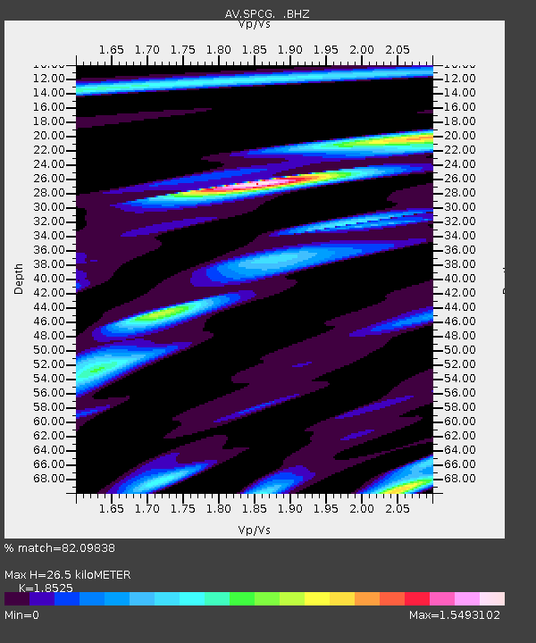
SPCG Mount Spurr - Capps Glacier - Earthquake Result Viewer

Earthquake location: Kermadec Islands Region
Earthquake latitude/longitude: -29.0/-176.2
Earthquake time(UTC): 2011/10/21 (294) 17:57:16 GMT
Earthquake Depth: 33 km
Earthquake Magnitude: 6.4 MB, 7.5 MS, 7.4 MW, 7.4 MW
Earthquake Catalog/Contributor: WHDF/NEIC
Network: AV Alaska Volcano Observatory
Station: SPCG Mount Spurr - Capps Glacier
Lat/Lon: 61.29 N/152.02 W
Elevation: 1329 m
Distance: 92.1 deg
Az: 11.431 deg
Baz: 201.076 deg
Ray Param: 0.041502077
Estimated Moho Depth: 26.5 km
Estimated Crust Vp/Vs: 1.85
Assumed Crust Vp: 6.566 km/s
Estimated Crust Vs: 3.544 km/s
Estimated Crust Poisson's Ratio: 0.29
Radial Match: 82.09838 %
Radial Bump: 400
Transverse Match: 83.74511 %
Transverse Bump: 400
SOD ConfigId: 424168
Insert Time: 2012-02-10 02:11:38.648 +0000
GWidth: 2.5
Max Bumps: 400
Tol: 0.001

Signal To Noise

ChannelStoNSTALTA
AV:SPCG: :BHZ:20111021T18:09:50.639978Z4.75245862.2918407E-64.8224314E-7
AV:SPCG: :BHN:20111021T18:09:50.639978Z1.87902811.0443748E-65.558058E-7
AV:SPCG: :BHE:20111021T18:09:50.639978Z0.61564952.8879901E-74.690965E-7
Arrivals
Ps3.5 SECOND
PpPs11 SECOND
PsPs/PpSs15 SECOND