You are here: Home > Network List > AV - Alaska Volcano Observatory Stations List
> Station OKSO South, Okmok Caldera, Alaska > Earthquake Result Viewer
OKSO South, Okmok Caldera, Alaska - Earthquake Result Viewer
| Earthquake location: |
Kermadec Islands Region |
| Earthquake latitude/longitude: |
-29.0/-176.2 |
| Earthquake time(UTC): |
2011/10/21 (294) 17:57:16 GMT |
| Earthquake Depth: |
33 km |
| Earthquake Magnitude: |
6.4 MB, 7.5 MS, 7.4 MW, 7.4 MW |
| Earthquake Catalog/Contributor: |
WHDF/NEIC |
|
| Network: |
AV Alaska Volcano Observatory |
| Station: |
OKSO South, Okmok Caldera, Alaska |
| Lat/Lon: |
53.36 N/168.16 W |
| Elevation: |
460 m |
|
| Distance: |
82.3 deg |
| Az: |
4.876 deg |
| Baz: |
187.136 deg |
| Ray Param: |
0.04693588 |
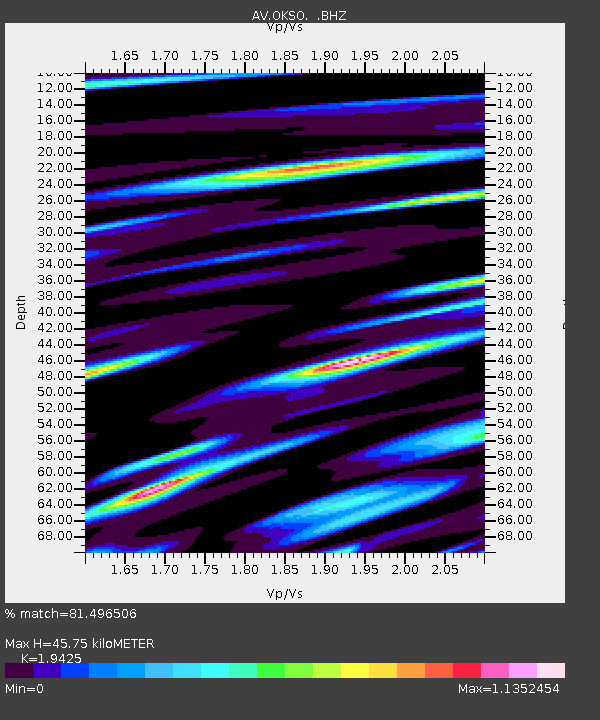
| Estimated Moho Depth: |
45.75 km |
| Estimated Crust Vp/Vs: |
1.94 |
| Assumed Crust Vp: |
5.88 km/s |
| Estimated Crust Vs: |
3.027 km/s |
| Estimated Crust Poisson's Ratio: |
0.32 |
|
| Radial Match: |
81.496506 % |
| Radial Bump: |
400 |
| Transverse Match: |
71.35225 % |
| Transverse Bump: |
400 |
| SOD ConfigId: |
424168 |
| Insert Time: |
2012-02-10 02:11:47.376 +0000 |
| GWidth: |
2.5 |
| Max Bumps: |
400 |
| Tol: |
0.001 |
|

Signal To Noise
| Channel | StoN | STA | LTA |
| AV:OKSO: :BHZ:20111021T18:09:03.219995Z | 7.18424 | 1.0168482E-5 | 1.4153873E-6 |
| AV:OKSO: :BHN:20111021T18:09:03.219995Z | 1.7702731 | 6.7809424E-6 | 3.83045E-6 |
| AV:OKSO: :BHE:20111021T18:09:03.219995Z | 1.3371549 | 3.5942066E-6 | 2.6879509E-6 |
| Arrivals |
| Ps | 7.5 SECOND |
| PpPs | 22 SECOND |
| PsPs/PpSs | 30 SECOND |


