You are here: Home > Network List > AZ - ANZA Regional Network Stations List
> Station FRD AZ.FRD > Earthquake Result Viewer
FRD AZ.FRD - Earthquake Result Viewer
| Earthquake location: |
Kermadec Islands Region |
| Earthquake latitude/longitude: |
-29.0/-176.2 |
| Earthquake time(UTC): |
2011/10/21 (294) 17:57:16 GMT |
| Earthquake Depth: |
33 km |
| Earthquake Magnitude: |
6.4 MB, 7.5 MS, 7.4 MW, 7.4 MW |
| Earthquake Catalog/Contributor: |
WHDF/NEIC |
|
| Network: |
AZ ANZA Regional Network |
| Station: |
FRD AZ.FRD |
| Lat/Lon: |
33.49 N/116.60 W |
| Elevation: |
1164 m |
|
| Distance: |
84.0 deg |
| Az: |
46.472 deg |
| Baz: |
229.473 deg |
| Ray Param: |
0.045771252 |
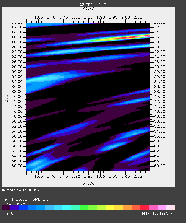
| Estimated Moho Depth: |
15.25 km |
| Estimated Crust Vp/Vs: |
2.10 |
| Assumed Crust Vp: |
6.264 km/s |
| Estimated Crust Vs: |
2.986 km/s |
| Estimated Crust Poisson's Ratio: |
0.35 |
|
| Radial Match: |
97.08397 % |
| Radial Bump: |
400 |
| Transverse Match: |
91.47394 % |
| Transverse Bump: |
400 |
| SOD ConfigId: |
424168 |
| Insert Time: |
2012-02-10 02:12:18.752 +0000 |
| GWidth: |
2.5 |
| Max Bumps: |
400 |
| Tol: |
0.001 |
|
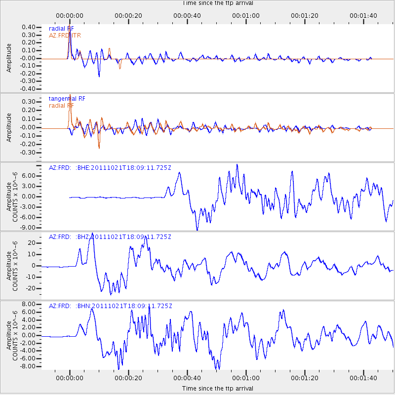
Signal To Noise
| Channel | StoN | STA | LTA |
| AZ:FRD: :BHZ:20111021T18:09:11.725Z | 44.125984 | 6.040638E-6 | 1.3689525E-7 |
| AZ:FRD: :BHN:20111021T18:09:11.725Z | 14.594167 | 1.4710675E-6 | 1.00798324E-7 |
| AZ:FRD: :BHE:20111021T18:09:11.725Z | 11.157696 | 1.2213346E-6 | 1.094612E-7 |
| Arrivals |
| Ps | 2.7 SECOND |
| PpPs | 7.4 SECOND |
| PsPs/PpSs | 10 SECOND |


