You are here: Home > Network List > AZ - ANZA Regional Network Stations List
> Station LVA2 AZ.LVA2 > Earthquake Result Viewer
LVA2 AZ.LVA2 - Earthquake Result Viewer
| Earthquake location: |
Kermadec Islands Region |
| Earthquake latitude/longitude: |
-29.0/-176.2 |
| Earthquake time(UTC): |
2011/10/21 (294) 17:57:16 GMT |
| Earthquake Depth: |
33 km |
| Earthquake Magnitude: |
6.4 MB, 7.5 MS, 7.4 MW, 7.4 MW |
| Earthquake Catalog/Contributor: |
WHDF/NEIC |
|
| Network: |
AZ ANZA Regional Network |
| Station: |
LVA2 AZ.LVA2 |
| Lat/Lon: |
33.35 N/116.56 W |
| Elevation: |
1435 m |
|
| Distance: |
83.9 deg |
| Az: |
46.603 deg |
| Baz: |
229.509 deg |
| Ray Param: |
0.045818213 |
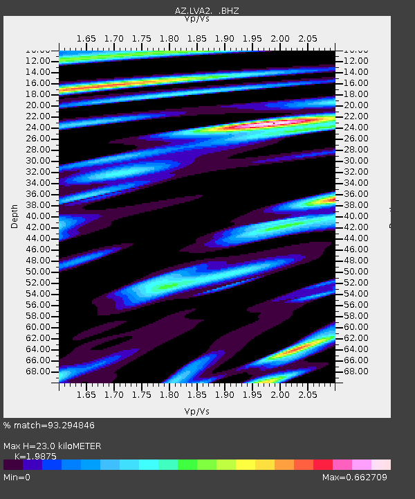
| Estimated Moho Depth: |
23.0 km |
| Estimated Crust Vp/Vs: |
1.99 |
| Assumed Crust Vp: |
6.264 km/s |
| Estimated Crust Vs: |
3.152 km/s |
| Estimated Crust Poisson's Ratio: |
0.33 |
|
| Radial Match: |
93.294846 % |
| Radial Bump: |
400 |
| Transverse Match: |
86.36272 % |
| Transverse Bump: |
400 |
| SOD ConfigId: |
424168 |
| Insert Time: |
2012-02-10 02:13:16.145 +0000 |
| GWidth: |
2.5 |
| Max Bumps: |
400 |
| Tol: |
0.001 |
|

Signal To Noise
| Channel | StoN | STA | LTA |
| AZ:LVA2: :BHZ:20111021T18:09:11.399988Z | 44.026302 | 6.1155847E-6 | 1.3890754E-7 |
| AZ:LVA2: :BHN:20111021T18:09:11.399988Z | 11.402124 | 1.460326E-6 | 1.280749E-7 |
| AZ:LVA2: :BHE:20111021T18:09:11.399988Z | 10.423912 | 1.6150203E-6 | 1.5493418E-7 |
| Arrivals |
| Ps | 3.7 SECOND |
| PpPs | 11 SECOND |
| PsPs/PpSs | 14 SECOND |


