You are here: Home > Network List > G - GEOSCOPE Stations List
> Station GRC Garchy, France > Earthquake Result Viewer
GRC Garchy, France - Earthquake Result Viewer

| Earthquake location: |
Turkmenistan |
| Earthquake latitude/longitude: |
39.6/54.8 |
| Earthquake time(UTC): |
2000/12/06 (341) 17:11:06 GMT |
| Earthquake Depth: |
30 km |
| Earthquake Magnitude: |
6.7 MB, 7.5 MS, 7.0 MW, 6.9 ME |
| Earthquake Catalog/Contributor: |
WHDF/NEIC |
|
| Network: |
G GEOSCOPE |
| Station: |
GRC Garchy, France |
| Lat/Lon: |
47.30 N/3.07 E |
| Elevation: |
191 m |
|
| Distance: |
37.8 deg |
| Az: |
299.212 deg |
| Baz: |
82.391 deg |
| Ray Param: |
0.07590438 |
| Estimated Moho Depth: |
39.0 km |
| Estimated Crust Vp/Vs: |
1.63 |
| Assumed Crust Vp: |
6.182 km/s |
| Estimated Crust Vs: |
3.787 km/s |
| Estimated Crust Poisson's Ratio: |
0.20 |
|
| Radial Match: |
89.62858 % |
| Radial Bump: |
400 |
| Transverse Match: |
94.27931 % |
| Transverse Bump: |
350 |
| SOD ConfigId: |
20082 |
| Insert Time: |
2010-02-26 22:35:56.798 +0000 |
| GWidth: |
2.5 |
| Max Bumps: |
400 |
| Tol: |
0.001 |
|
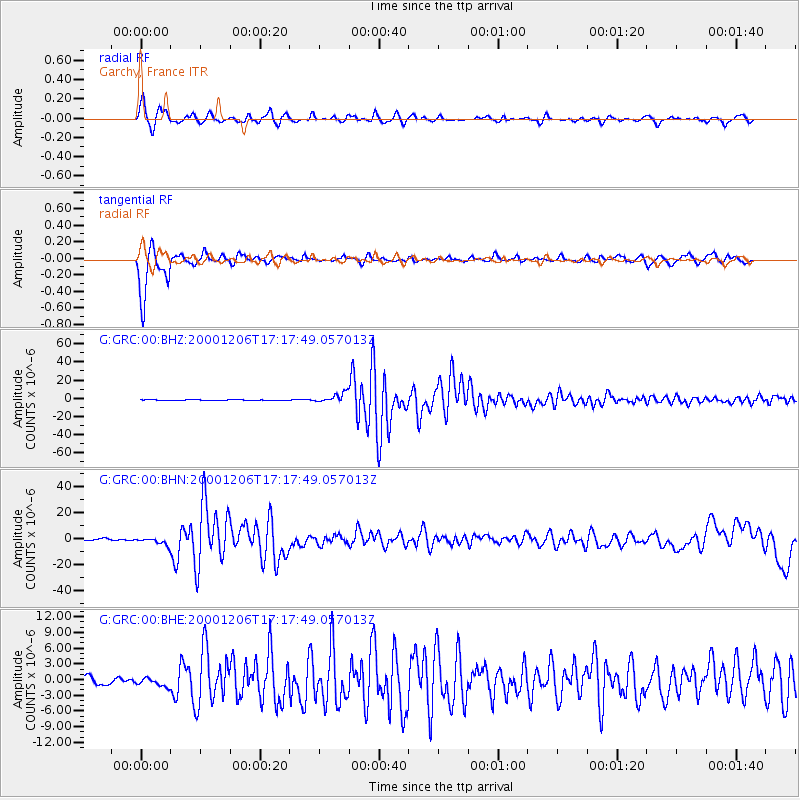
Signal To Noise
| Channel | StoN | STA | LTA |
| G:GRC:00:BHN:20001206T17:17:49.057013Z | 4.5725827 | 2.8536692E-6 | 6.240826E-7 |
| G:GRC:00:BHE:20001206T17:17:49.057013Z | 1.3814452 | 8.0564337E-7 | 5.831888E-7 |
| G:GRC:00:BHZ:20001206T17:17:49.057013Z | 9.610348 | 5.2615906E-6 | 5.474922E-7 |
| Arrivals |
| Ps | 4.3 SECOND |
| PpPs | 15 SECOND |
| PsPs/PpSs | 20 SECOND |


